Life
|
Life
City of Gotha
Coordinates: 50 ° 54 ′ 48 ″ N , 10 ° 42 ′ 10 ″ E
|
||
|---|---|---|
| Height : | 330 m | |
| Area : | 7.37 km² | |
| Residents : | 733 (2014) | |
| Population density : | 99 inhabitants / km² | |
| Incorporation : | April 9, 1994 | |
| Postal code : | 99867 | |
| Area code : | 03621 | |
|
Location of Uelleben in Thuringia |
||
Uelleben is a district of Gotha in Thuringia .
geography
The place is about four kilometers south of the center of the core city Gotha between the Boxberg and the Seeberg . The district has a size of 737 hectares, of which 12.8 hectares are building and open space and 591 hectares are used for agricultural purposes.
history
The first documentary mention of Uelleben is for the year 874. The place came into the possession of Georgenthal Monastery in the 13th century , which is about 10 kilometers (as the crow flies) south-southwest of Uelleben. Up until the abolition of the monastery in the 16th century, there was a monastery-owned farm in addition to the manor - a grangie . The relatively fertile soil was also used for growing flax and woad. It was not until 1830 that Uelleben was placed under the Gotha office, previously it was a "care village" in the Tenneberg office . The district is located on Coburger Strasse (also Nürnberger Strasse ), a medieval trade route that led from Gotha via Uelleben, Emleben , Herrenhof , to the Oberhofer Pass and on via Zella-Mehlis , Suhl and Hildburghausen to Coburg , it was the main connecting route for the two Residence of the Duchy of Saxe-Coburg and Gotha .
After 1945 resettlers and displaced persons streamed west along the motorway route. Some stayed in the Gotha region and settled down. After the expropriation of the landowners, the LPG was founded around 1960 (it was dissolved in 1990). The smaller neighboring village Boilstädt was from July 1, 1950 to April 30, 1990 a district of the municipality of Uelleben. Uelleben was an independent municipality until it was incorporated into Gotha on April 9, 1994.
Attractions
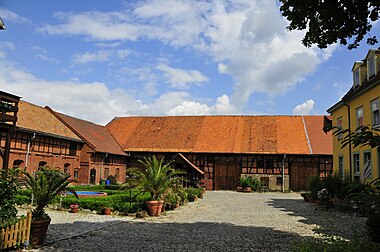
In Boilstädter Straße there is the courtyard of a manor that was given to the meritorious Dr. phil. Ewald Troch (1879–1952) belonged. The building complex is a listed building, as is the neighboring St. John's Church , a village church with a choir tower and double gallery that was renovated around 1640. Two housing estates (“Hinter dem Teichdamm” and “Schulweg”), which were built in the 1990s, adjoin the historical location in the north and south.
The Noah's Ark animal shelter in the district of Gotha is located on Boilstädter Straße .
traffic
You can get to Uelleben from Gotha via Landesstraße 2146. Federal motorway 4 runs south of the town , the closest driveway is the Gotha junction.
Nature reserves
On the southern edge of the district is the Birkigt , a wooded area and part of the Boxberg area. Also on the other side of the autobahn is the four-hectare natural monument “Uelleber Ried”, one of the largest reed-covered marshland in the Gotha district. The protection goal is the preservation and promotion of a valuable humid habitat with a species-rich world of swamps and water birds. In 1998 the district administration worked out a maintenance and development plan for this purpose.
Web links
Individual evidence
- ↑ a b c zoning plan of the city of Gotha (text part). (PDF; 10.0 MB) In: City of Gotha Land Use Plan (2006). Retrieved May 26, 2013 .
- ^ Wolfgang Kahl : First mention of Thuringian cities and villages - A manual . Rockstuhl Verlag, Bad Langensalza 2010, ISBN 978-3-86777-202-0 .
- ↑ 2. Ordinance amending the district and community boundaries in the State of Thuringia of June 26, 1950 Government Gazette for the State of Thuringia No. 18/1950, pp. 193–196
- ↑ Federal Statistical Office (Ed.): Municipalities 1994 and their changes since 01.01.1948 in the new federal states . Metzler-Poeschel, Stuttgart 1995, ISBN 3-8246-0321-7 , pp. 422 .
- ↑ Gotha City Archives and www.wissensguru.de


