Urspring (Steingaden)
|
Origin
Community Steingaden
Coordinates: 47 ° 42 ′ 8 ″ N , 10 ° 50 ′ 7 ″ E
|
|
|---|---|
| Height : | 750 m above sea level NHN |
| Residents : | 283 (1987) |
| Incorporation : | April 1, 1939 |
| Postal code : | 86989 |
| Area code : | 08862 |
|
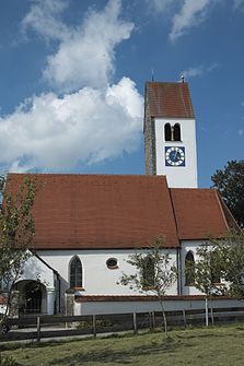
Filial church of St. Maria Magdalena
|
|
Ursprung is a district of the municipality of Steingaden in the Upper Bavarian district of Weilheim-Schongau .
location
The church village is about two kilometers west of Steingaden. The Lechstausee Urspring begins just north-west of the village . The district road WM 18 leads from the south running state road 2059 into the place.
history
In the course of the administrative reforms in the Kingdom of Bavaria in 1818, Urspring became an independent political municipality and belonged to the Schongau district court . Districts were:
|
On April 1, 1939, Urspring merged with two neighboring communities to form the Steingaden community.
Architectural monuments
- Filial church of St. Maria Magdalena , Romanesque core
See also: List of architectural monuments in Urspring
Web links
Commons : Urspring - collection of images, videos and audio files
- Origin in the location database of the Bayerische Landesbibliothek Online . Bavarian State Library
Individual evidence
- ^ Localities directory for the Free State of Bavaria, territorial status 1928
- ^ Wilhelm Volkert (ed.): Handbook of Bavarian offices, communities and courts 1799–1980 . CH Beck, Munich 1983, ISBN 3-406-09669-7 , p. 566 .

