Utah Beach
When the Allies landed in Normandy in World War II, Utah Beach was the code name for a French stretch of coast almost five kilometers in length between Pouppeville and La Madeleine at the foot of the Cotentin peninsula , in the Plain countryside in the Manche department . It was the most westerly landing section, in the area of which, according to the initial plans, no landing attack was planned. However, since the Allies needed a deep-water port as soon as possible after the start of the landing - and Cherbourg on the northern tip of the peninsula seemed the most suitable - Utah Beach was included in the invasion plan. The next landing sections were Omaha , Gold , Juno and Sword Beach and the Pointe du Hoc gun emplacement .
The defense of the coast on the German side was subject to the approximately 50 kilometers wide "Bayeux Defense Area" (main thrust), which bordered the Vire estuary to the east and stretched to just east of Arromanches-les-Bains in the east, the German 352nd Infantry Division under Lieutenant General Dietrich Kraiss and other naval and air force units. To the west of it, under Lieutenant General Karl-Wilhelm von Schlieben ( Cherbourg ), the area of the 709th Division to be defended with the attack section Utah Beach joined.
planning
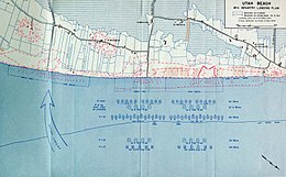
The night before the landing, units of the 82nd and 101st Airborne Divisions (101st US Airborne Division) were deployed in the hinterland of Utah Beach to secure the flanks of the landing beaches. The first phase of landing on Utah Beach involved four waves. With the first wave , two landing heads were to be established in a total of 20 landing craft , each manned by a 30-man combat team of the 8th Infantry Regiment of the 4th US Infantry Division . The ten boats on the right flank had the task of taking the stretch of beach Tare Green , which was to be located exactly opposite the strong German defensive area in the dunes near Vareville . The boats on the left flank were intended for the Uncle Red beach section , which was about 900 m further south.
The entire operation built on the first wave of landing, which was scheduled for 6:30 in the morning. Around the same time, eight landing craft, each equipped with four floating tanks , were to be dispatched.
The second wave was in the plan of another 32 landing craft with battle groups, pioneers and demolition squads that should eliminate the underwater obstacles.
After another 15 minutes, the third wave with tanks should go ashore. It was to be followed immediately by the fourth wave of attacks, which consisted of two engineer battalions . Their task was to clean the beach from bugs and mines up to the high water line .
D-Day
Preparation for landing
Before the start of the landing on D-Day , June 6, 1944 , there was a massive bombing of the German coastal positions by ship artillery and air raids. At 5:30 a.m. - one hour before the start of the landing - American and British battleships, cruisers and destroyers as well as the Dutch gunboat Soemba began shelling the German coastal fortifications and artillery positions. The ships included the battleship USS Nevada , which was badly damaged in the Japanese attack on Pearl Harbor . At 6:00 am 269 intervened medium bomber of the type B-26 Marauder , seven German defensive positions with a total of 4,404 bombs.
In contrast to Omaha Beach , many of the German defense positions were destroyed or severely damaged by the shelling of Utah Beach . In addition, many of the surviving defenders were so battered by the hour-long bombardment that they could not offer any serious resistance.
Two hours before the start of the landing, units of the 4th and 24th US Cavalry Squadrons occupied the Saint Marcouf Islands - off Utah Beach - on which a German outpost was suspected. Contrary to expectations, the attackers did not find any German troops, but still suffered some losses from mines. By 5:30 a.m., the two islands were completely in Allied hands. Before the start of the attack on the islands, an advance party of four men armed only with knives went ashore to mark the landing zones. These men were probably the first Allied soldiers to set foot on French soil by sea on June 6, 1944.
H-hour
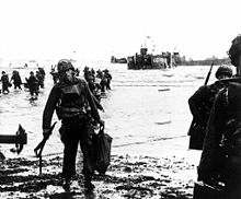
Shortly before 6:30 a.m., the first stormtroopers approached the southern edge of Utah Beach with 20 boats. When they were 250 to 350 meters from the coast, smoke signals were fired on the boats to signal the naval units to stop shelling the beach. The 300 men of the 2nd Battalion of the 8th Infantry Regiment were the first to reach the coast at 6:31 a.m., having to walk the last 100 meters to the beach in the water. A short time later, the 1st Battalion went ashore north of it.
A few minutes later, 28 of the 32 buoyant Sherman DD tanks of the 70th US tank battalion reached the coast and fired at the remaining German defensive positions. Four tanks were lost when their landing craft hit a mine and sank. The effective tank support of the first wave of landing was another significant difference to the landing on Omaha Beach and also helped to keep Allied losses low here. In contrast to Omaha Beach, the tanks were released by the landing craft just three kilometers from the coast and coped with the calmer seas near the coast without any problems.
At this time, pioneers and special forces in the Navy began to clear mines and beach obstacles in Utah Beach so that the following units could land safely and without delay and advance inland.
However, the first wave landed 1,800 meters south of the planned landing section. This was the result of a strong lateral current that pushed the landing craft to the south. As the coast was covered by clouds of smoke as a result of the previous bombardment, the landing craft crews lacked orientation points for course correction.
The wrong landing location could actually have led to great confusion, which however did not occur. Although the individual orders could not be carried out in detail, Brigadier General Theodore Roosevelt, Jr. , the deputy commander of the 4th US Infantry Division, had the situation under control and attacked the strong German positions that could be reached. This enabled the Americans to quickly advance to the main roads in the hinterland and attack the German troops from there.
The soldiers faced relatively little resistance, so that the losses of 197 men could be described as relatively low. Some German artillery positions shot at the ships at sea, but were unable to cause any damage. By the end of the day, more than 20,000 soldiers with 1,700 vehicles had set foot on French soil on the Utah Beach section.
museum
The Landungs-Museum Utah Beach (French: Musée du Débarquement Utah Beach ), which opened in 1962, is located at the point where a German bunker secured the coastline. It was destroyed by the American attack on the morning of June 6, 1944. In particular, the US troops involved here are remembered: the 4th US Infantry Division and its 8th Infantry Regiment, the 101st US Airborne Division .
In addition to a landing craft and many smaller war-related exhibits, the museum is showing one of the few remaining medium-weight American bombers of the Martin B 26 “ Marauder ” type. It was reopened in 2011 after an expansion.
Sports
Utah Beach was the destination of the 1st stage of the Tour de France 2016 on July 2, 2016 .
literature
- Joseph Balkoski: Utah Beach. The Amphibious Landing and Airborne Operations on D-Day, June 6, 1944. Stackpole Books, 2005, ISBN 0-8117-0144-1 .
- Mark R. Henry: D-Day 1944 (2). Utah Beach & US Airborne Landings (Campaign). Motorbooks International, 2004, ISBN 1-84176-365-9 .
- James Arnold: Operation Overlord. Utah Beach & the US Airborne Divisions June 6, 1944. 004 (Order of Battle, 4). Ravelin, 1994, ISBN 1-898994-03-X .
- Antony Beevor: D-Day - The Battle of Normandy. C. Bertelsmann, Gütersloh 2010, ISBN 978-3-570-10007-3 .
Web links
- Musée du Débarquement Utah Beach
- Utah Beach Landing Museum
- Website u. a. to Utah Beach (website Battletours.de by Jan-H. Maida, German)
Coordinates: 49 ° 25 ′ 5 ″ N , 1 ° 10 ′ 35 ″ W.


