
Pointe du Hoc

The Pointe du Hoc (also incorrectly called Pointe du Hoe ) is a 500 meter long and about 30 meter high section on the cliff on the Calvados coast in Normandy in France , about 6.4 kilometers from the beach section named Omaha Beach by the allies . On D-Day , during Operation Overlord in World War II , an American ranger battalion eliminated German positions at the Pointe du Hoc.
background

Even before the USA entered the war in December 1941 , an involvement in the European theater of war was foreseeable. At the Washington Conference in 1941, Franklin D. Roosevelt and Winston Churchill confirmed that a landing on the European continent would be required, via the Mediterranean , from Turkey to the Balkans , or by landings in Western Europe . The war against the German Wehrmacht was given priority over the war in the Pacific against Japan .
In order to relieve the Red Army , Joseph Stalin had urged the Western Allies to open a second front . At the Tehran Conference in November 1943, landings in northern and southern France, operations Overlord and Anvil , were therefore decided. In contrast to Winston Churchill, who - allegedly due to a lack of transport - pressed for an abandonment of Operation Anvil, Stalin favored the originally planned pincer movement. The Red Army had used this tactic successfully on several occasions. The Americans also thought an invasion of southern France would make sense, as the ports of Toulon and Marseille would offer good supplies and supplies for the Allied troops in France. The implementation of a simultaneous invasion of southern France (Operation Anvil) was abandoned and carried out as Operation Dragoon in August 1944.
At the Casablanca Conference , in the absence of Stalin, it was decided to establish a combined headquarters , the Supreme Headquarters Allied Expeditionary Force . The leadership of the Supreme Allied Commander should Dwight D. Eisenhower accept. Eisenhower's chief of staff was named Chief of Staff to the Supreme Allied Commander of Lieutenant-General Frederick E. Morgan , who was to lead the planning for Operation Overlord. Bernard Montgomery took over the management of the landing units . The naval forces were to command Admiral Bertram Ramsay , the air forces from Air Chief Marshal Trafford Leigh-Mallory . The main objective of the operation was set to capture the French city of Caen, as well as other large cities in Normandy.
The plan


At the Pointe du Hoc, which is often incorrectly stated in US Army documents as "Pointe du Hoe" , there was a German position with six 155 mm field cannons that guarded the beach and thus the American landing forces on the beach sections Utah and Omaha Beach could have been targeted. Although the positions were often attacked by bomber units and naval artillery, the strong fortifications withstood their fire. Therefore, the US 2nd Ranger Battalion was given the order to destroy the guns on the morning of D-Day .
The position was built by the German Todt Organization . The area was protected by two 2 cm anti-aircraft cannons , various machine gun positions, minefields and barbed wire barriers, as well as by the cliffs . According to reports from the Resistance, there should be 125 SS soldiers and 85 gunners in the positions. The battery was manned by the Army Coast Artillery Department in 1260 . There was also an observation and fire control post nearby, which was connected to a radar station five kilometers away at the Pointe de la Percée.
The ranger battalion, consisting of 225 men, was led by Lieutenant Colonel James Earl Rudder . The plan provided for the three ranger companies (D, E and F) to land at the foot of the cliffs from the sea and then climb up the rock walls with ropes, ladders and the like. After that, the troops should conquer the upper cliff . The attack was to be carried out before the main Allied landings. It was scheduled to begin at 6:30 a.m., and a second group of eight companies would follow half an hour later. They were then to be relieved of troops who landed at the "Dog Green" section of Omaha Beach .
The rangers were trained by British commandos for the attack on the Isle of Wight . Fifty of the rangers had previously participated in Operation Jubilee in the 1942 attack on Dieppe .
execution

After some initial setbacks due to bad weather, the operation was postponed for a day. Everyone had to stay at sea. The next day the weather was still bad, but the green light was given.
Around 4:30 a.m., the soldiers of the 2nd Ranger Battalion boarded ten British landing craft and made their way to the fortress. But already in the first few minutes, various boats had problems with the water level and the heavy sea . Around 5 o'clock a boat could no longer withstand this and capsized. Due to the adverse conditions, 19 soldiers were killed.

After some initial setbacks due to bad weather and navigation problems, the Americans landed at the foot of the cliffs 40 minutes later than planned, at 7:10 a.m., with the attack supported by Allied destroyers . However, the Germans resisted doggedly and threw boulders and hand grenades at the Americans who were climbing up. At around 7.15 a.m., the first rangers reached the cliff level with the destroyed flak position and prepared themselves for defense. After another 20 minutes all men were upstairs.

The guns had already been removed, however, possibly because of the bombing that started the invasion. The rangers regrouped on the cliff, set up defensive positions and sent some men further inland to look for the guns. One of the patrols found the guns unguarded and without ammunition in an orchard about a kilometer southwest of the Pointe du Hoc. The patrol destroyed the guns with thermite - grenades , causing the fall and tilt mechanism were destroyed. The second patrol came in and destroyed an ammunition dump.
After the rangers had built a bridgehead on the edge of the Pointe du Hoc , they were attacked several times by German troops on June 6 and 7 and encircled 200 meters from the top of the cliff . The US 116th Infantry Regiment and the US 5th Ranger Battalion , which came from Omaha Beach, moved about 900 meters closer to the rangers. On the night of June 7th to 8th, the commander of the German troops surrounding the rangers ordered to withdraw, whereupon the American reinforcements were able to break through from Omaha Beach.
By the end of the second day, the unit had shrunk from more than 225 men to 90 men still fit for action.
After the battle, some rangers were convinced that French civilians had stood by the German soldiers. Many were charged with shooting the Americans or serving as artillery monitors for the Germans. Some of them were executed by the rangers.
aftermath

Due to his services in Normandy, Rudder was promoted to general some time later and then headed the school of the ranger regiment in Texas .
A museum in Grandcamp-Maisy and a memorial today commemorate the battle for the Pointe du Hoc. Many of the ancient fortifications are still visible today on the bomb crater-strewn cliffs.
For the 60th anniversary of the landing in Normandy, the area was redesigned and given to the USA. A large car park, bus parking spaces and a viewing platform allow tourists to explore the battle site today.
The Pointe du Hoc today

The site of the former battlefield was given to the United States of America on January 11, 1979 for permanent use. The ABMC (American Battle Monuments Commission) has been maintaining the site ever since, trying to keep it in its 1944 state.
After around 10 meters of the rocky coast had eroded over the last 60 years, the ABMC decided, after a study in 2004, to save this historic site. The battery's fire control center in particular is at risk of slipping into the depths due to the crumbling rock below. In spring 2010 the ranger memorial was removed and an access road to the fire control center was built. Since then, the washouts under the Pointe du Hoc have been filled with concrete. In addition, horizontal and vertical stabilization holes will be drilled around the fire control station in order to stabilize it permanently. The construction work was completed at the end of 2010. The ranger memorial was erected again.
gallery

Crater and bunker at the memorial before the development work for the 2006 anniversary
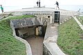
Entrance to the fire control station, 2015

Safeguarding work on the Pointe du Hoc, 2010

Safeguarding work on the Pointe du Hoc, 2010

View down to the beach, 2015

Sheep keeping the area clear, 2015


literature
- Douglas Brinkley: The Boys of Pointe du Hoc. Ronald Reagan, D-Day, and the US Army 2nd Ranger Battalion. William Morrow & Company, New York NY 2005, ISBN 0-06-056527-6 .
- Will Fowler: D-Day. The First 24 Hours. Brown Books, London, 2003, ISBN 1-897884-97-4 (German: D-day. The longest day. Tosa, Vienna 2004, ISBN 3-85492-855-6 ).
- Tony Hall (Ed.): Operation "Overlord". The landing of the Allies in Normandy in 1944. Motorbuch-Verlag, Stuttgart 2004, ISBN 3-613-02407-1 .
- JoAnna M. McDonald: The Liberation of Pointe Du Hoc. The 2nd US Ranger at Normandy. June 6-8, 1944. Rank and File Publications, Redondo Beach CA 2000, ISBN 1-888967-06-4 .
- Dan Parry: D-Day. The dramatic story of the greatest invasion of all time. The official book of the Imperial War Museum. Vgs, Cologne 2004, ISBN 3-8025-1618-4 .
- Dan van der Vat: D-Day. The Allied landing in Normandy. Heyne, Munich 2004, ISBN 3-89910-199-5 .
- Michael Schmelke: Alert coast: German naval, army and air force batteries in coastal defense 1939-1945 . Dörfler Verlag, 2004, ISBN 978-3-89555-178-9 .
Web links
- More information about the Pointe du Hoc
- Information at worldwar2history.info - Part 1, Part 2, Part 3 (English)
- Information at normandiememoire.com (English)
- Photos (English)
- Detailed information (English)
- Info (english)
swell
- ^ Antony Beevor : D-Day: The Battle for Normandy . Penguin, New York 2009, p. 106.
- ↑ http://www.normandiememoire.com/lieux_historiques/index_bis.php?marq=1&id=186&lg=de&parcours=2 ( Page no longer available , search in web archives ) Info: The link was automatically marked as defective. Please check the link according to the instructions and then remove this notice. ; Retrieved November 4, 2008.
Coordinates: 49 ° 23 ′ 45 ″ N , 0 ° 59 ′ 20 ″ W.