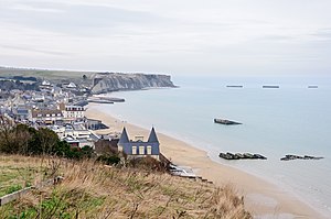
Arromanches-les-Bains
| Arromanches-les-Bains | ||
|---|---|---|

|
|
|
| region | Normandy | |
| Department | Calvados | |
| Arrondissement | Bayeux | |
| Canton | Courseulles-sur-Mer | |
| Community association | Bayeux intercom | |
| Coordinates | 49 ° 20 ′ N , 0 ° 37 ′ W | |
| height | 0-55 m | |
| surface | 1.37 km 2 | |
| Residents | 489 (January 1, 2017) | |
| Population density | 357 inhabitants / km 2 | |
| Post Code | 14117 | |
| INSEE code | 14021 | |
| Website | www.arromanches.com | |
 Arromanches-les-Bains |
||
Arromanches-les-Bains is a French commune in the Calvados department ( Normandy region ) with 489 inhabitants (as of January 1, 2017).
geography
Arromanches is located on the coast of the English Channel , around eight kilometers northeast of Bayeux and 25 kilometers northwest of Caen . The neighboring municipalities include Saint-Côme-de-Fresné and Tracy-sur-Mer .
history
During the Allied landings in Normandy during World War II in 1944, Arromanches was in the Gold Beach landing section . After the landing, one of the two artificial harbors ( Mulberry B ) was built off the coast , via which troops and supplies were brought ashore. Remnants of this port can be viewed today.
Population development
| year | 1962 | 1968 | 1975 | 1982 | 1990 | 1999 | 2007 | 2016 |
| Residents | 298 | 339 | 355 | 395 | 409 | 552 | 609 | 503 |
| Sources: Cassini and INSEE | ||||||||
economy
The main source of income for the place is tourism. In addition to a campsite, numerous sport and leisure activities are offered.
Attractions
- Musée du Débarquement
- Arromanches cinema 360 °
- Saint-Pierre church, built in the mid-19th century in neo-Romanesque style


