Colleville-sur-Mer
| Colleville-sur-Mer | ||
|---|---|---|
|
|
||
| region | Normandy | |
| Department | Calvados | |
| Arrondissement | Bayeux | |
| Canton | Trévières | |
| Community association | Isigny-Omaha Intercom | |
| Coordinates | 49 ° 21 ′ N , 0 ° 51 ′ W | |
| height | 0-79 m | |
| surface | 6.93 km 2 | |
| Residents | 175 (January 1, 2017) | |
| Population density | 25 inhabitants / km 2 | |
| Post Code | 14710 | |
| INSEE code | 14165 | |
| Website | www.collevillesurmer.fr | |
 Main street in Colleville-sur-Mer |
||
Colleville-sur-Mer is a French commune with 175 inhabitants (as of January 1, 2017) in the Calvados department in the Normandy region . It belongs to the Arrondissement of Bayeux and the canton of Trévières .
geography
Colleville-sur-Mer is located about 20 kilometers northwest of Bayeux on the Côte de Nacre (" mother-of-pearl ") in Bessin on a hill above Omaha Beach .
history
Although more recent archaeological finds have provided evidence of settlement as early as Gallo-Roman times, the place name of Colleville is of Viking - Norman origin. It is made up of the Scandinavian anthroponym Koli and the Latin name villa in the sense of villa rustica , country estate.
The place is mentioned in writing for the first time in 1082 in the Cartulaire de la Trinité under the name Colevilla. In 1269 the place received municipal rights, now under the name Collevilla.
The medieval castle of Château Perrey du Moustier was razed by the English during the Hundred Years War . A castle was built in the 18th century by Comte Charles Léonor de Marguerye and his son, but it was badly damaged during the fighting during the Allied landings in June 1944 and the remains of it were finally removed in 1953. The Romanesque church Notre-Dame de l'Assomption from the 12th century was also badly damaged, but was largely rebuilt true to the original after the end of the war. It is classified as a monument historique .
During D-Day , Colleville was above the Fox Green and Easy Red sectors (further west towards Saint-Laurent-sur-Mer ) of the Omaha Beach landing section . In the morning hours of June 6, 1944, the 1st and 29th US Infantry Divisions landed here and initially encountered heavy German resistance. It wasn't until around 8 p.m. that the first bridgehead was established on the hill west of Colleville. The place itself was not taken until the following day by the 2nd Battalion of the 18th Regiment of the 1st US Infantry Division . On the same day, 16 German soldiers were killed by three French resistance fighters from the tower of the church within two hours . The tower was brought down by two shots from an 8.8 cm rocket launcher , and two resistance fighters died.
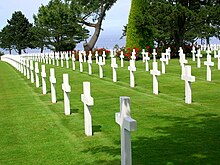
On June 8, 1944, the first American military cemetery was built on the site of the bridgehead, and today the much-visited Normandy American Cemetery with 9,386 graves and a memorial for 1,557 missing people is located there .
Population development
| year | 1962 | 1968 | 1975 | 1982 | 1990 | 1999 | 2006 | 2016 |
| Residents | 225 | 195 | 180 | 169 | 146 | 172 | 167 | 176 |
| Sources: Cassini and INSEE | ||||||||
Web links
- Official website (French)
- Colleville-sur-Mer at faehreensucher.com


