
Plan query
| Plan query | ||
|---|---|---|
|
||
| region | Normandy | |
| Department | Calvados | |
| Arrondissement | Bayeux | |
| Canton | Trévières | |
| Community association | Isigny-Omaha Intercom | |
| Coordinates | 49 ° 9 ′ N , 0 ° 50 ′ W | |
| height | 60-143 m | |
| surface | 14.37 km 2 | |
| Residents | 241 (January 1, 2017) | |
| Population density | 17 inhabitants / km 2 | |
| Post Code | 14490 | |
| INSEE code | 14506 | |

Planquery is a commune in the department of Calvados in the region of Normandy with 241 inhabitants (as of January 1 2017). Planquery belongs to the Arrondissement of Bayeux and the canton of Trévières .
geography
Planquery is located about 22 kilometers southwest of Bayeux . Planquery is surrounded by the neighboring communities of Balleroy-sur-Drôme in the north, Castillon in the north and north-east, Cahagnolles in the east, Foulognes in the east and south-east, Sallen in the south, Cormolain in the south and south-west and La Bazoque in the west and south-west.
Population development
| 1962 | 1968 | 1975 | 1982 | 1990 | 1999 | 2006 | 2013 |
|---|---|---|---|---|---|---|---|
| 284 | 277 | 251 | 217 | 255 | 241 | 219 | 218 |
| Source: Cassini and INSEE | |||||||
Attractions
- Saint-André church from the 13th century
- Command of the Tepel Knights of Baugy with chapel ( Monument historique since 1995), founded in 1148
- 17th century castle
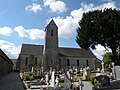
Saint-André church

lock


literature
- Le Patrimoine des Communes du Calvados. Volume 1, Flohic Editions, Paris 2001, ISBN 2-84234-111-2 , pp. 119-121.
Web links
Commons : Planquery - collection of images, videos and audio files