
Sully (Calvados)
| Sully | ||
|---|---|---|
|
||
| region | Normandy | |
| Department | Calvados | |
| Arrondissement | Bayeux | |
| Canton | Bayeux | |
| Community association | Bayeux intercom | |
| Coordinates | 49 ° 18 ′ N , 0 ° 44 ′ W | |
| height | 18-58 m | |
| surface | 4 km 2 | |
| Residents | 140 (January 1, 2017) | |
| Population density | 35 inhabitants / km 2 | |
| Post Code | 14400 | |
| INSEE code | 14680 | |

Sully is a French municipality with 140 inhabitants (as of January 1 2017) in the department of Calvados in the region Normandy (before 2016 Basse-Normandie ); it belongs to the Arrondissement of Bayeux and the Canton of Bayeux . The inhabitants are called Sulliens .
geography
Sully is about four kilometers northwest of Bayeux city center near the Atlantic coast . Sully is surrounded by the neighboring communities Maisons in the north, Vaux-sur-Aure in the east and northeast, Vaucelles in the south and Tour-en-Bessin in the west.
Population development
| year | 1962 | 1968 | 1975 | 1982 | 1990 | 1999 | 2006 | 2013 |
| Residents | 174 | 147 | 121 | 132 | 134 | 148 | 120 | 134 |
| Source: Cassini and INSEE | ||||||||
Attractions
- Notre-Dame-de-la-Nativité church from the 12th century, Monument historique
- Sully Castle from the 18th century
- Boissy mansion from the 16th century
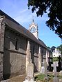
Notre-Dame-de-la-Nativité church
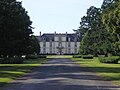
Sully Castle


literature
- Le Patrimoine des Communes du Calvados. Volume 1, Flohic Editions, Paris 2001, ISBN 2-84234-111-2 , pp. 172-174.
Web links
Commons : Sully - collection of images, videos and audio files