
Englesqueville-la-Percée
| Englesqueville-la-Percée | ||
|---|---|---|
|
||
| region | Normandy | |
| Department | Calvados | |
| Arrondissement | Bayeux | |
| Canton | Trévières | |
| Community association | Isigny-Omaha Intercom | |
| Coordinates | 49 ° 23 ′ N , 0 ° 57 ′ W | |
| height | 0-42 m | |
| surface | 7.88 km 2 | |
| Residents | 104 (January 1, 2017) | |
| Population density | 13 inhabitants / km 2 | |
| Post Code | 14710 | |
| INSEE code | 14239 | |

Englesqueville-la-Percée is a commune in the department of Calvados in the region of Normandy with 104 inhabitants (as of January 1 2017). Englesqueville-la-Percée belongs to the Arrondissement of Bayeux and the canton of Trévières . The inhabitants are called Englesquevillais .
geography
Englesqueville-la-Percée is located about 32 kilometers west-northwest of Bayeux and about 45 kilometers northeast of Saint-Lô on the Atlantic coast . Englesqueville-la-Percée is surrounded by the neighboring communities of Formigny La Bataille in the east, Asnières-en-Bessin in the south-east, Deux-Jumeaux in the south and Saint-Pierre-du-Mont in the west and north-west.
history
The coast at Englesqueville-la-Percée is part of the western coast of Omaha Beach . On June 6, 1944, the Allied landings in Normandy took place here.
Population development
| 1962 | 1968 | 1975 | 1982 | 1990 | 1999 | 2006 | 2013 |
|---|---|---|---|---|---|---|---|
| 191 | 180 | 158 | 121 | 125 | 97 | 93 | 85 |
| Source: Cassini and INSEE | |||||||
Attractions
- Saint-Vigor church from the 12th century
- Beaumont-le-Richard Castle

Saint-Vigor church
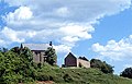
Beaumont-le-Richard Castle

