
Tour-en-Bessin
| Tour-en-Bessin | ||
|---|---|---|
.svg)
|
|
|
| region | Normandy | |
| Department | Calvados | |
| Arrondissement | Bayeux | |
| Canton | Trévières | |
| Community association | Isigny-Omaha Intercom | |
| Coordinates | 49 ° 18 ′ N , 0 ° 47 ′ W | |
| height | 20-77 m | |
| surface | 10.31 km 2 | |
| Residents | 658 (January 1, 2017) | |
| Population density | 64 inhabitants / km 2 | |
| Post Code | 14400 | |
| INSEE code | 14700 | |

Tour-en-Bessin is a commune in the department of Calvados in the region of Normandy with 658 inhabitants (as of January 1 2017). Tour-en-Bessin is part of the Bayeux arrondissement and the Trévières canton . The inhabitants are called Tourois .
geography
Tour-en-Bessin is about nine kilometers west-northwest of Bayeux . Tour-en-Bessin is surrounded by the neighboring communities of Étréham in the north and north-west, Maisons in the north and north-east, Sully in the east and north-east, Vaucelles in the east, Cussy in the east and south-east, Cottun in the south, Crouay in the west and south-west and Mosles in the West and northwest.
The National Route 13 runs through the municipality .
Population development
| 1962 | 1968 | 1975 | 1982 | 1990 | 1999 | 2006 | 2013 |
|---|---|---|---|---|---|---|---|
| 414 | 452 | 418 | 421 | 512 | 504 | 585 | 608 |
| Source: Cassini and INSEE | |||||||
Attractions
- Saint-Pierre church from the 11th century, monument historique
- Vaulaville Castle from the 18th century, Monument historique
- Tour-en-Bessin castle from the 18th century
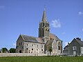
Saint-Pierre church

Vaulaville Castle
.jpg)

Web links
Commons : Tour-en-Bessin - Collection of images, videos and audio files