
Le Molay-Littry
| Le Molay-Littry | ||
|---|---|---|

|
|
|
| region | Normandy | |
| Department | Calvados | |
| Arrondissement | Bayeux | |
| Canton | Trévières | |
| Community association | Isigny-Omaha Intercom | |
| Coordinates | 49 ° 15 ′ N , 0 ° 52 ′ W | |
| height | 25-112 m | |
| surface | 27.12 km 2 | |
| Residents | 2,988 (January 1, 2017) | |
| Population density | 110 inhabitants / km 2 | |
| Post Code | 14330 | |
| INSEE code | 14370 | |
| Website | ville-molay-littry.fr | |
 Le Molay-Littry Town Hall |
||

Le Molay-Littry is a commune in the department of Calvados in the region of Normandy with 2,988 inhabitants (as of January 1 2017). Le Molay-Littry is part of the Caen arrondissement and the Trévières canton . The inhabitants are called Molystriens .
geography
The municipality is located on the eastern edge of the forest of Cerisy , 13 km west of the city of Bayeux and 20 km northeast of Saint-Lô . Le Molay-Littry is surrounded by the neighboring communities Saonnet and Saon in the north, Le Breuil-en-Bessin in the north and north-east, Crouay in the north-east, Le Tronquay in the east, Montfiquet in the south, Cerisy-la-Forêt in the south and south-west, Tournières to the west and south-west and Saint-Martin-de-Blagny to the west and north-west.
The municipality's train station is on the Mantes-la-Jolie – Cherbourg railway .
Population development
| 1962 | 1968 | 1975 | 1982 | 1990 | 1999 | 2006 | 2012 |
|---|---|---|---|---|---|---|---|
| 1,630 | 1,576 | 2,302 | 2,522 | 2,584 | 2,657 | 2,950 | 3,080 |
Attractions
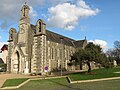
- Saint Clair Church in Le Molay, built in 1862
- Saint Germain Church in Littry
- Chapel of the mine
- Saint-Nicolas chapel in Le Molay, built in the 12th century
- Le Molay Castle
- Mill with museum
- Le Bel Air grotto
Chapel of the mine

Saint Clair Church
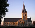
Saint Germain Church

Saint-Nicolas chapel

Mine museum


Partner communities
Partnerships exist with the German municipality of Dahlenburg in Lower Saxony and the British municipality of Bovey Tracey in Devonshire ( England ) .
literature
- Le Patrimoine des Communes du Calvados. Volume 1, Flohic Editions, Paris 2001, ISBN 2-84234-111-2 , pp. 106-115.