
Castillon (Calvados)
| Castillon | ||
|---|---|---|
|
||
| region | Normandy | |
| Department | Calvados | |
| Arrondissement | Bayeux | |
| Canton | Trévières | |
| Community association | Isigny-Omaha Intercom | |
| Coordinates | 49 ° 12 ′ N , 0 ° 48 ′ W | |
| height | 39-132 m | |
| surface | 11.02 km 2 | |
| Residents | 344 (January 1, 2017) | |
| Population density | 31 inhabitants / km 2 | |
| Post Code | 14490 | |
| INSEE code | 14140 | |
_mairie.JPG) Town Hall (Mairie) of Castillon |
||

Castillon is a commune in the department of Calvados in the region of Normandy with 344 inhabitants (as of January 1 2017). Castillon belongs to the Arrondissement of Bayeux and the Canton of Trévières . The inhabitants are called Castillonais .
geography
Castillon is about 17 kilometers southwest of Bayeux . Castillon is surrounded by the neighboring communities of Balleroy-sur-Drôme in the north, Le Tronquay in the north, Noron-la-Poterie in the north-east, Saint-Paul-du-Vernay in the east, Cahagnolles in the south and south-east, Planquery in the south and south-west and Balleroy -sur-Drôme to the west and north-west.
Population development
| 1962 | 1968 | 1975 | 1982 | 1990 | 1999 | 2006 | 2013 |
|---|---|---|---|---|---|---|---|
| 331 | 325 | 298 | 294 | 284 | 308 | 295 | 332 |
| Source: Cassini and INSEE | |||||||
Attractions
- Gallic oppidum
- Saint-Cassien church from the 15th century
- Castle from 1762, monument historique , with water mill
- Castillon-Plantbessin Park, laid out in 1985
- Sully Bridge, a historic monument since 1990

Saint-Cassien church
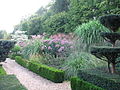
Castillon-Plantbessin Park

Sully Bridge
_Fa%C3%A7ade_occidentale_de_l%27%C3%A9glise.JPG)
.jpg)

literature
- Le Patrimoine des Communes du Calvados. Volume 1, Flohic Editions, Paris 2001, ISBN 2-84234-111-2 , pp. 92-93.
Web links
Commons : Castillon - collection of images, videos and audio files