
Blay
| Blay | ||
|---|---|---|
|
||
| region | Normandy | |
| Department | Calvados | |
| Arrondissement | Bayeux | |
| Canton | Trévières | |
| Community association | Isigny-Omaha Intercom | |
| Coordinates | 49 ° 16 ′ N , 0 ° 50 ′ W | |
| height | 15-81 m | |
| surface | 7.14 km 2 | |
| Residents | 383 (January 1, 2017) | |
| Population density | 54 inhabitants / km 2 | |
| Post Code | 14400 | |
| INSEE code | 14078 | |
 City Hall (Mairie) of Blay |
||

Blay is a French municipality with 383 inhabitants (at January 1, 2017) in the department of Calvados in the region of Normandy . It belongs to the Arrondissement of Bayeux and the canton of Trévières . The inhabitants are called Blaviens .
geography
Blay is about 17 kilometers west of Bayeux . Blay is surrounded by the neighboring municipalities of Mandeville-en-Bessin in the north and northwest, Mosles in the north, Crouay in the east, Le Breuil-en-Bessin in the south and southwest and Saon in the west.
Population development
| 1962 | 1968 | 1975 | 1982 | 1990 | 1999 | 2006 | 2015 |
|---|---|---|---|---|---|---|---|
| 236 | 184 | 217 | 215 | 239 | 267 | 300 | 386 |
| Source: Cassini and INSEE | |||||||
Attractions
- Saint-Pierre church from the 13th century
- Former rectory
- Cléronde mansion, built in 1639, monument historique
- Mill

Saint-Pierre church
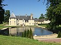
Cléronde mansion


Web links
Commons : Blay - collection of images, videos and audio files