
Ryes
| Ryes | ||
|---|---|---|

|
|
|
| region | Normandy | |
| Department | Calvados | |
| Arrondissement | Bayeux | |
| Canton | Bayeux | |
| Community association | Bayeux intercom | |
| Coordinates | 49 ° 19 ′ N , 0 ° 37 ′ W | |
| height | 15-59 m | |
| surface | 9.59 km 2 | |
| Residents | 517 (January 1, 2017) | |
| Population density | 54 inhabitants / km 2 | |
| Post Code | 14400 | |
| INSEE code | 14552 | |

Ryes is a French municipality with 517 inhabitants (as of January 1 2017) in the department of Calvados in the region Normandy (before 2016 Basse-Normandie ). The municipality belongs to the Arrondissement of Bayeux and the canton of Bayeux (until 2015 canton Ryes ). The inhabitants are called Rissois .
geography
Ryes is located near the coast of the English Channel about six kilometers northeast of Bayeux and about 23 kilometers northwest of Caen . Ryes is surrounded by the neighboring communities of Tracy-sur-Mer in the north and north-west, Arromanches-les-Bains in the north, Saint-Côme-de-Fresné in the east and north-east, Meuvaines in the east and south-east, Le Manoir in the south and south-east, Sommervieu in the south and southwest and Magny-en-Bessin in the west.
history
| year | 1962 | 1968 | 1975 | 1982 | 1990 | 1999 | 2006 | 2013 |
|---|---|---|---|---|---|---|---|---|
| Residents | 350 | 377 | 338 | 317 | 421 | 450 | 474 | 502 |
Attractions
- Saint-Martin church from the 12th / 13th centuries Century, since 1840 Monument historique
- 17th century mansion of Le Pavillon
- British war cemetery
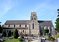
Saint Martin Church

Manor house of Le Pavillon

