
La Bazoque (Calvados)
| La Bazoque | ||
|---|---|---|
|
||
| region | Normandy | |
| Department | Calvados | |
| Arrondissement | Bayeux | |
| Canton | Trévières | |
| Community association | Isigny-Omaha Intercom | |
| Coordinates | 49 ° 10 ′ N , 0 ° 52 ′ W | |
| height | 57-142 m | |
| surface | 10.14 km 2 | |
| Residents | 183 (January 1, 2017) | |
| Population density | 18 inhabitants / km 2 | |
| Post Code | 14490 | |
| INSEE code | 14050 | |

La Bazoque is a commune in the department of Calvados in the region Normandy (before 2016 Basse-Normandie ) with 183 inhabitants (at January 1, 2017). La Bazoque belongs to the Arrondissement of Bayeux and the canton of Trévières ( Balleroy until 2015 ).
geography
La Bazoque is located about 27 kilometers southwest of Bayeux on the Drôme . La Bazoque is surrounded by the neighboring communities of Montfiquet in the north and north-west, Balleroy-sur-Drôme in the north-east, Planquery in the east, Cormolain in the south and south-east, Saint-Germain-d'Elle in the south-west, Bérigny in the west and south-west and Litteau in the west .
Population development
| 1962 | 1968 | 1975 | 1982 | 1990 | 1999 | 2006 | 2013 |
|---|---|---|---|---|---|---|---|
| 224 | 193 | 158 | 157 | 143 | 153 | 177 | 171 |
| Source: Cassini and INSEE | |||||||
Attractions
- Saint Martin Church
- Mill Les Essarts
- Carrière Castle

Saint Martin Church
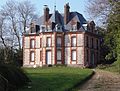
Carrière Castle


literature
- Le Patrimoine des Communes du Calvados. Volume 1, Flohic Editions, Paris 2001, ISBN 2-84234-111-2 , pp. 85-86.
Web links
Commons : La Bazoque - collection of images, videos and audio files