
Berigny
| Berigny | ||
|---|---|---|
|
||
| region | Normandy | |
| Department | Some | |
| Arrondissement | Saint-Lô | |
| Canton | Pont-Hébert | |
| Community association | Saint-Lô Agglo | |
| Coordinates | 49 ° 9 ′ N , 0 ° 56 ′ W | |
| height | 73-159 m | |
| surface | 12.15 km 2 | |
| Residents | 425 (January 1, 2017) | |
| Population density | 35 inhabitants / km 2 | |
| Post Code | 50810 | |
| INSEE code | 50046 | |

Bérigny is a French municipality with 425 inhabitants (as of January 1 2017) in the department of Manche in the region of Normandy . The municipality belongs to the canton of Pont-Hébert (until 2015: canton of Saint-Clair-sur-l'Elle ) in the arrondissement of Saint-Lô . The inhabitants are called Bérignais .
geography
Bérigny is located about eleven kilometers east-northeast of Saint-Lô . Bérigny is surrounded by the neighboring communities of Montfiquet in the north and northeast, Litteau in the east and northeast, La Bazoque in the east, Saint-Germain-d'Elle in the south and southeast, Notre-Dame-d'Elle in the south, and Saint-Jean-des -Baisants to the south-west, Saint-Pierre-de-Semilly to the west and south-west, and Saint-Georges-d'Elle to the west and north-west.
Population development
| 1962 | 1968 | 1975 | 1982 | 1990 | 1999 | 2006 | 2013 |
| 386 | 372 | 314 | 340 | 359 | 367 | 363 | 419 |
Culture and sights
- Saint-Gildard Church
- Saint-Quentin-d'Elle Castle
- Saint-Quentin-d'Elle chapel from the 13th / 14th centuries Century, monument historique since 1993
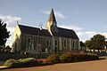
Saint-Gildard Church

Saint-Quentin Chapel

Saint-Quentin-d'Elle Castle


