
Saint-Fromond
| Saint-Fromond | ||
|---|---|---|
|
||
| region | Normandy | |
| Department | Some | |
| Arrondissement | Saint-Lô | |
| Canton | Pont-Hébert | |
| Community association | Saint-Lô Agglo | |
| Coordinates | 49 ° 13 ′ N , 1 ° 5 ′ W | |
| height | 0-53 m | |
| surface | 15.52 km 2 | |
| Residents | 769 (January 1, 2017) | |
| Population density | 50 inhabitants / km 2 | |
| Post Code | 50620 | |
| INSEE code | 50468 | |

Saint-Fromond is a French municipality with 769 inhabitants (at January 1, 2017) in the department of Manche in the region of Normandy . It belongs to the canton of Pont-Hébert and the arrondissement of Saint-Lô .
geography
The Vire touches the village center on the Cotentin peninsula on its eastern side. The former canal Canal de Vire et Taute branches off to the north of the municipality . Saint-Fromond borders in the north-west on Montmartin-en-Graignes , in the north-east on Isigny-sur-Mer with Neuilly-la-Forêt , in the east on Airel , in the south on Cavigny , in the south-west on Le Dézert and in the west on Saint-Jean -de-daye .
Population development
| year | 1962 | 1968 | 1975 | 1982 | 1990 | 1999 | 2008 | 2015 |
|---|---|---|---|---|---|---|---|---|
| Residents | 838 | 852 | 773 | 592 | 662 | 668 | 730 | 774 |
Attractions
- Saint-Fromond priory church
- Bridge over the Vire
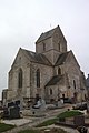
Saint-Fromond priory church

Bridge over the Vire
.jpg)

Web links
Commons : Saint-Fromond - Collection of images, videos and audio files