
Domjean
| Domjean | ||
|---|---|---|
|
||
| region | Normandy | |
| Department | Some | |
| Arrondissement | Saint-Lô | |
| Canton | Condé-sur-Vire | |
| Community association | Saint-Lô Agglo | |
| Coordinates | 48 ° 59 ′ N , 1 ° 2 ′ W | |
| height | 30-178 m | |
| surface | 16.57 km 2 | |
| Residents | 1,038 (January 1, 2017) | |
| Population density | 63 inhabitants / km 2 | |
| Post Code | 50420 | |
| INSEE code | 50164 | |
 Mairie Domjean |
||

Domjean is a French commune with 1,038 inhabitants (at January 1, 2017) in the department of Manche in the region of Normandy . It belongs to the arrondissement of Saint-Lô and the canton of Condé-sur-Vire .
It borders in the north-west on Condé-sur-Vire with Troisgots , in the north-east on Torigny-les-Villes with Brectouville and Giéville , in the east on Saint-Louet-sur-Vire , in the south-east on Beuvrigny , in the south on Fourneaux , in the west Tessy-Bocage with Tessy-sur-Vire and Fervaches .
Population development
| year | 1962 | 1968 | 1975 | 1982 | 1990 | 1999 | 2008 | 2015 |
|---|---|---|---|---|---|---|---|---|
| Residents | 904 | 838 | 748 | 748 | 822 | 820 | 997 | 1087 |
Attractions
- Angotière Castle, historical monument since 1969
- Saint-Jean-Baptiste church
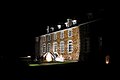
Angotière Castle

Saint-Jean-Baptiste church
.JPG)

Web links
Commons : Domjean - collection of images, videos and audio files