Saint-Clair-sur-l'Elle
| Saint-Clair-sur-l'Elle | ||
|---|---|---|
|
|
||
| region | Normandy | |
| Department | Some | |
| Arrondissement | Saint-Lô | |
| Canton | Pont-Hébert | |
| Community association | Saint-Lô Agglo | |
| Coordinates | 49 ° 12 ′ N , 1 ° 2 ′ W | |
| height | 12-95 m | |
| surface | 7.99 km 2 | |
| Residents | 953 (January 1, 2017) | |
| Population density | 119 inhabitants / km 2 | |
| Post Code | 50680 | |
| INSEE code | 50455 | |
| Website | http://50455.campagnol.fr/ | |
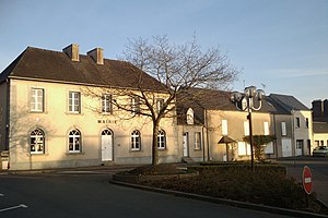
 Town hall (Mairie) of Saint-Clair-sur-l'Elle |
||
Saint-Clair-sur-l'Elle is a French municipality with 953 inhabitants (as of January 1 2017) in the department of Manche in the region of Normandy . The municipality belongs to the canton of Pont-Hébert (until 2015: canton of Saint-Clair-sur-l'Elle ) in the arrondissement of Saint-Lô . The inhabitants are called Saint-Clairais .
geography
Saint-Clair-sur-l'Elle is located about nine kilometers north-northeast of Saint-Lô . The Elle River limits the community to the northeast. Saint-Clair-sur-l'Elle is surrounded by the neighboring communities of Moon-sur-Elle in the north and west, Saint-Jean-de-Savigny in the east, Couvains in the south-east, Villiers-Fossard in the south and La Meauffe in the south-west.
Population development
| 1962 | 1968 | 1975 | 1982 | 1990 | 1999 | 2006 | 2013 |
| 482 | 568 | 630 | 741 | 797 | 864 | 850 | 938 |
Culture and sights
- Saint-Clair church from the 11th century
Web links
Commons : Saint-Clair-sur-l'Elle - Collection of images, videos and audio files

