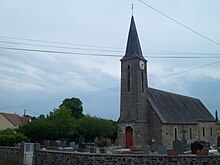
Saint-Jean-d'Elle
| Saint-Jean-d'Elle | ||
|---|---|---|
|
|
||
| region | Normandy | |
| Department | Some | |
| Arrondissement | Saint-Lô | |
| Canton |
Condé-sur-Vire Pont-Hébert |
|
| Community association | Saint-Lô Agglo | |
| Coordinates | 49 ° 6 ′ N , 0 ° 58 ′ W | |
| height | 49-217 m | |
| surface | 33.72 km 2 | |
| Residents | 2,460 (January 1, 2017) | |
| Population density | 73 inhabitants / km 2 | |
| Post Code | 50810 | |
| INSEE code | 50492 | |
Saint-Jean-d'Elle is a commune in the French department of Manche in Normandy . It belongs to the cantons of Condé-sur-Vire and Pont-Hébert in the arrondissement of Saint-Lô . It was created as Commune nouvelle by a decree of November 26, 2015 with effect from January 1, 2016 by merging the previous municipalities of Saint-Jean-des-Baisants , Notre-Dame-d'Elle , Précorbin , Rouxeville and Vidouville .
structure
| District | former INSEE code |
Area (km²) | Population (2016) |
|---|---|---|---|
| Notre-Dame-d'Elle | 50380 | 2.85 | 186 |
| Precorbin | 50414 | 7.21 | 524 |
| Rouxeville | 50441 | 5.83 | 344 |
| Saint-Jean-des-Baisants (administrative headquarters) | 50492 | 13.37 | 1,252 |
| Vidouville | 50635 | 4.46 | 134 |
Attractions
- Saint-Jean-Baptiste Church, Monument historique
- Saint-Aubin Church, Monument historique
- Notre-Dame-de-la-Délivrance church, built around 1960 according to plans by architects Jacques Traverse and Mélik Nafilyan
- Saint Martin Church
- Saint-Pierre church in Vidouville from the 14th century
- Chapel in Saint-Jean-des-Baisants
Web links
Commons : Saint-Jean-d'Elle - Collection of images, videos and audio files
Individual evidence
- ↑ Population figures retrospectively from January 1, 2016

