
Le Dézert
| Le Dézert | ||
|---|---|---|
|
||
| region | Normandy | |
| Department | Some | |
| Arrondissement | Saint-Lô | |
| Canton | Pont-Hébert | |
| Community association | Saint-Lô Agglo | |
| Coordinates | 49 ° 12 ′ N , 1 ° 10 ′ W | |
| height | 8-52 m | |
| surface | 14.58 km 2 | |
| Residents | 589 (January 1, 2017) | |
| Population density | 40 inhabitants / km 2 | |
| Post Code | 50620 | |
| INSEE code | 50161 | |

Le Dézert is a French municipality with 589 inhabitants (at January 1, 2017) in the department of Manche in the region of Normandy . It belongs to the canton of Pont-Hébert and the arrondissement of Saint-Lô .
Neighboring municipalities are Graignes-Mesnil-Angot in the northwest, Le Mesnil-Véneron in the north, Saint-Jean-de-Daye in the northeast, Saint-Fromond in the east, Cavigny in the southeast and Pont-Hébert in the southwest.
Population development
| year | 1962 | 1968 | 1975 | 1982 | 1990 | 1999 | 2008 | 2015 |
|---|---|---|---|---|---|---|---|---|
| Residents | 609 | 623 | 608 | 563 | 521 | 500 | 559 | 573 |
Attractions
- Saint-Ortaire Castle, historic monument since 2004
- Saint-Ortaire chapel, monument historique since 2014

Saint-Ortaire Castle
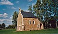
Saint-Ortaire chapel


Web links
Commons : Le Dézert - collection of images, videos and audio files