
Dangy
| Dangy | ||
|---|---|---|
|
||
| region | Normandy | |
| Department | Some | |
| Arrondissement | Saint-Lô | |
| Canton | Saint-Lô-2 | |
| Community association | Saint-Lô Agglo | |
| Coordinates | 49 ° 3 ′ N , 1 ° 13 ′ W | |
| height | 70-161 m | |
| surface | 9.93 km 2 | |
| Residents | 672 (January 1, 2017) | |
| Population density | 68 inhabitants / km 2 | |
| Post Code | 50750 | |
| INSEE code | 50159 | |
 Mairie Dangy |
||

Dangy is a French commune with 672 inhabitants (as of January 1, 2017) in the Manche department in the Normandy region . It belongs to the arrondissement of Saint-Lô and the canton of Saint-Lô-2 .
geography
In addition to the main settlement, Dangy also includes the hamlet of Pont-Brocard.
Neighboring municipalities are Carantilly in the northwest, Quibou in the north, Saint-Martin-de-Bonfossé in the east, Bourgvallées in the southeast, Notre-Dame-de-Cenilly in the southwest and Cerisy-la-Salle in the west.
Population development
| year | 1962 | 1968 | 1975 | 1982 | 1990 | 1999 | 2008 | 2015 |
|---|---|---|---|---|---|---|---|---|
| Residents | 549 | 533 | 515 | 565 | 605 | 604 | 650 | 647 |
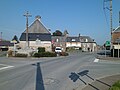
Dangy
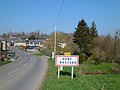
Pont-Brocard
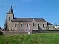
Saint-Jean-Baptiste church in Pont-Brocard


Web links
Commons : Dangy - collection of images, videos and audio files