
Notre-Dame-de-Cenilly
| Notre-Dame-de-Cenilly | ||
|---|---|---|
.svg)
|
|
|
| region | Normandy | |
| Department | Some | |
| Arrondissement | Coutances | |
| Canton | Quettreville-sur-Sienne | |
| Community association | Coutances Mer et Bocage | |
| Coordinates | 49 ° 0 ′ N , 1 ° 15 ′ W | |
| height | 50-141 m | |
| surface | 25.23 km 2 | |
| Residents | 648 (January 1, 2017) | |
| Population density | 26 inhabitants / km 2 | |
| Post Code | 50210 | |
| INSEE code | 50378 | |
 Town hall (Mairie) of Notre-Dame-de-Cenilly |
||

Notre-Dame-de-Cenilly is a French municipality with 648 inhabitants (as of January 1 2017) in the department of Manche in the region of Normandy . It belongs to the canton of Quettreville-sur-Sienne in the Arrondissement of Coutances . The inhabitants are called Cenillais .
geography
Notre-Dame-de-Cenilly is located 18 kilometers south-east of Saint-Lô in the Norman Bocage , a landscape criss-crossed with a large number of hedges that delimit agricultural fields. The Soulles River limits the municipality to the north. Neighboring communities are Cerisy-la-Salle in the north, Dangy in the north-east, Bourgvallées in the east, Le Guislain in the south-east, Hambye in the south, Saint-Martin-de-Cenilly in the south-west, Roncey in the west and south-west and Montpinchon in the north-west.
Population development
| 1962 | 1968 | 1975 | 1982 | 1990 | 1999 | 2006 | 2013 |
|---|---|---|---|---|---|---|---|
| 955 | 919 | 743 | 690 | 660 | 690 | 690 | 671 |
| Source: Cassini and INSEE | |||||||
Culture and sights
- Notre-Dame church from the 13th century
- Marcambie Castle from the 16th century
- Bouillon Castle from the 18th century
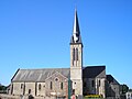
Notre-Dame church
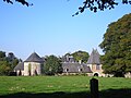
Marcambie Castle


Personalities
- Henri Varin de la Brunelière (1900–1983), Archbishop of Fort-de-France and Saint-Pierre
- Anne Heurgon-Desjardins (1899–1977), daughter of Paul Desjardins , founder of the Center culturel international