
Savigny (Manche)
| Savigny | ||
|---|---|---|

|
|
|
| region | Normandy | |
| Department | Some | |
| Arrondissement | Coutances | |
| Canton | Quettreville-sur-Sienne | |
| Community association | Coutances Mer et Bocage | |
| Coordinates | 49 ° 3 ′ N , 1 ° 20 ′ W | |
| height | 35-135 m | |
| surface | 10.2 km 2 | |
| Residents | 446 (January 1, 2017) | |
| Population density | 44 inhabitants / km 2 | |
| Post Code | 50210 | |
| INSEE code | 50569 | |
_-_Mairie.jpg) Mairie de Savigny |
||

Savigny is a French municipality with 446 inhabitants (at January 1, 2017) in the department of Manche in the region of Normandy . It belongs to the canton of Quettreville-sur-Sienne in the Arrondissement of Coutances .
geography
Savigny is 11 kilometers east of Coutances in the Norman Bocage , a landscape criss-crossed with a large number of hedges that delimit agricultural fields. Neighboring municipalities are Le Lorey in the northeast, Cametours in the east, Montpinchon in the south, Ouville in the southwest, Belval in the west and Camprond in the northwest.
The departmental road D972 and the Lison – Lamballe railway , which connect Coutances with Saint-Lô , run on the northern border of the municipality.
Culture and sights
- Church of Our Lady of Savigny from the 11th century with frescoes from the 14th century. The building has been classified as a Monument historique ('historical monument') since 1970 .

Church Notre-Dame de Savigny
(11th century)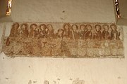
Last Supper fresco
(14th century)


Web links
Individual evidence
- ↑ Notre-Dame de Savigny church in the Base Mérimée of the French Ministry of Culture (French)