
Baupte
| Baupte | ||
|---|---|---|
|
||
| region | Normandy | |
| Department | Some | |
| Arrondissement | Coutances | |
| Canton | Carentan | |
| Community association | Communauté de communes de la Baie du Cotentin | |
| Coordinates | 49 ° 19 ′ N , 1 ° 22 ′ W | |
| height | 2–26 m | |
| surface | 2.29 km 2 | |
| Residents | 431 (January 1, 2017) | |
| Population density | 188 inhabitants / km 2 | |
| Post Code | 50500 | |
| INSEE code | 50036 | |
.jpg) Baupte |
||

Baupte is a French municipality with 431 inhabitants (at January 1, 2017) in the department of Manche in the region of Normandy . It belongs to the Arrondissement Coutances and the Canton of Carentan .
location
The municipality is located on the Cotentin peninsula . Neighboring municipalities are Montsenelle in the north-west, Appeville in the north-east, Auvers in the south-east and Saint-Jores in the south-west.
Population development
| year | 1962 | 1968 | 1975 | 1982 | 1990 | 1999 | 2008 | 2015 |
|---|---|---|---|---|---|---|---|---|
| Residents | 343 | 422 | 501 | 520 | 431 | 422 | 444 | 432 |
Attractions
- Notre-Dame church
- The station was used from 1894 to 1971 for regular passenger traffic. He later became part of the Train Touristique du Cotentin .
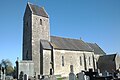
Notre-Dame church

Baupte station
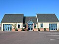
Mairie Baupte


Web links
Commons : Baupte - collection of images, videos and audio files