
Roncey
| Roncey | ||
|---|---|---|
|
||
| region | Normandy | |
| Department | Some | |
| Arrondissement | Coutances | |
| Canton | Quettreville-sur-Sienne | |
| Community association | Coutances Mer et Bocage | |
| Coordinates | 49 ° 1 ′ N , 1 ° 19 ′ W | |
| height | 37-148 m | |
| surface | 12.15 km 2 | |
| Residents | 804 (January 1, 2017) | |
| Population density | 66 inhabitants / km 2 | |
| Post Code | 50210 | |
| INSEE code | 50437 | |
 Town Hall (Mairie) of Roncey |
||

Roncey is a French municipality with 804 inhabitants (as of January 1 2017) in the department of Manche in the region of Normandy . It belongs to the canton of Quettreville-sur-Sienne (until 2015: canton of Cerisy-la-Salle ) in the Arrondissement of Coutances . The inhabitants are called Roncyais .
geography
Roncey is located about 22 kilometers southeast of Saint-Lô and about ten kilometers southwest of Coutances in the Norman Bocage , a landscape criss-crossed with a large number of hedges that delimit agricultural fields. The Vanne limits the community in the south. Neighboring municipalities are Montpinchon in the north, Notre-Dame-de-Cenilly in the northeast, Saint-Martin-de-Cenilly in the east and southeast, Saint-Denis-le-Gast and Grimesnil in the south, Quettreville-sur-Sienne with Guéhébert in the southwest as well Saint-Denis-le-Vêtu to the west and north-west.
Population development
| 1962 | 1968 | 1975 | 1982 | 1990 | 1999 | 2006 | 2013 |
|---|---|---|---|---|---|---|---|
| 740 | 695 | 617 | 680 | 708 | 800 | 770 | 842 |
| Source: Cassini and INSEE | |||||||
Attractions
- Saint-Côme-et-Saint-Damien church, built around 1950 after the previous building was bombed in 1944
- Letenneur mausoleum from 1900
- Chapel of Les Constils
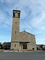
Saint-Côme-et-Saint-Damien church

Les Costils Chapel

Letenneur mausoleum


.JPG)
Personalities
- Émile Eudes (1843–1888), leader of the Paris Commune