
Saint-Patrice-de-Claids
| Saint-Patrice-de-Claids | ||
|---|---|---|
|
||
| region | Normandy | |
| Department | Some | |
| Arrondissement | Coutances | |
| Canton | Créances | |
| Community association | Communauté de communes Côte Ouest Center Manche | |
| Coordinates | 49 ° 14 ′ N , 1 ° 26 ′ W | |
| height | 9-34 m | |
| surface | 5.58 km 2 | |
| Residents | 176 (January 1, 2017) | |
| Population density | 32 inhabitants / km 2 | |
| Post Code | 50190 | |
| INSEE code | 50533 | |

Saint-Patrice-de-Claids is a French municipality with 176 inhabitants (as of January 1 2017) in the department of Manche in the region of Normandy . It belongs to the Arrondissement of Coutances and the canton of Créances .
It borders on Laulne to the north, Gorges to the north-east, Gonfreville to the east, Périers to the south-east, Millières to the south and Vesly to the west .
Population development
| year | 1962 | 1968 | 1975 | 1982 | 1990 | 1999 | 2008 | 2015 |
|---|---|---|---|---|---|---|---|---|
| Residents | 252 | 241 | 189 | 165 | 180 | 163 | 157 | 165 |
Attractions
- Saint-Patrice Church
- Manoir de La Guerrie , mansion

Saint-Patrice Church
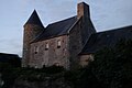
Manoir de La Guerrie


Web links
Commons : Saint-Patrice-de-Claids - collection of images, videos and audio files