
Doville
| Doville | ||
|---|---|---|
|
||
| region | Normandy | |
| Department | Some | |
| Arrondissement | Coutances | |
| Canton | Créances | |
| Community association | Communauté de communes Côte Ouest Center Manche | |
| Coordinates | 49 ° 20 ′ N , 1 ° 32 ′ W | |
| height | 2–128 m | |
| surface | 11.09 km 2 | |
| Residents | 321 (January 1, 2017) | |
| Population density | 29 inhabitants / km 2 | |
| Post Code | 50250 | |
| INSEE code | 50166 | |

Doville is a commune in the French department of Manche in Normandy . It belongs to the canton of Créances and the Arrondissement Coutances . It borders on Catteville to the northwest , Saint-Sauveur-le-Vicomte to the northeast, Varenguebec to the east, La Haye to the southeast, Saint-Nicolas-de-Pierrepont to the southwest and Saint-Sauveur-de-Pierrepont to the west .
Population development
| year | 1962 | 1968 | 1975 | 1982 | 1990 | 1999 | 2008 | 2015 |
|---|---|---|---|---|---|---|---|---|
| Residents | 271 | 270 | 266 | 247 | 253 | 256 | 290 | 317 |
Attractions
- Saint Martin Church
- Notre-Dame chapel
- Ruins of a guard house, monument historique since 1992

Notre-Dame chapel
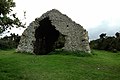
Ruins of a guard house

Mairie Doville

Natural park near Doville

Saint Martin Church

View to Mont Doville in the north of the municipality marker


.jpg)
.jpg)
Web links
Commons : Doville - collection of images, videos and audio files