
Saint-Jean-de-Savigny
| Saint-Jean-de-Savigny | ||
|---|---|---|
|
||
| region | Normandy | |
| Department | Some | |
| Arrondissement | Saint-Lô | |
| Canton | Pont-Hébert | |
| Community association | Saint-Lô Agglo | |
| Coordinates | 49 ° 12 ′ N , 1 ° 0 ′ W | |
| height | 17-101 m | |
| surface | 7.58 km 2 | |
| Residents | 446 (January 1, 2017) | |
| Population density | 59 inhabitants / km 2 | |
| Post Code | 50680 | |
| INSEE code | 50491 | |
 Town hall (Mairie) of Saint-Jean-de-Savigny |
||

Saint-Jean-de-Savigny is a French municipality with 446 inhabitants (as of January 1 2017) in the department of Manche in the region of Normandy . The municipality belongs to the canton of Pont-Hébert (until 2015: canton of Saint-Clair-sur-l'Elle ) in the arrondissement of Saint-Lô . The inhabitants are called Savignais .
geography
Saint-Jean-de-Savigny is located about eleven kilometers northeast of Saint-Lô . The Elle River limits the municipality to the north. Saint-Jean-de-Savigny is surrounded by the neighboring communities of Sainte-Marguerite-d'Elle in the north, Cerisy-la-Forêt in the east, Couvains in the south, Saint-Clair-sur-l'Elle in the west and Moon-sur- Elle to the west and northwest.
Population development
| 1962 | 1968 | 1975 | 1982 | 1990 | 1999 | 2006 | 2013 |
| 366 | 342 | 294 | 323 | 315 | 278 | 336 | 408 |
Culture and sights
- Saint-Jean-Baptiste church from the 19th century
- Clouay Chapel from the 18th century
- Rochefort Castle

Saint-Jean-Baptiste church
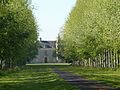
Rochefort Castle


Web links
Commons : Saint-Jean-de-Savigny - Collection of images, videos and audio files