
Percy-en-Normandy
| Percy-en-Normandy | ||
|---|---|---|
|
||
| region | Normandy | |
| Department | Some | |
| Arrondissement | Saint-Lô | |
| Canton | Villedieu-les-Poêles | |
| Community association | Communauté de communes de Villedieu Intercom | |
| Coordinates | 48 ° 55 ′ N , 1 ° 11 ′ W | |
| height | 60-275 m | |
| surface | 48.32 km 2 | |
| Residents | 2,583 (January 1, 2017) | |
| Population density | 53 inhabitants / km 2 | |
| Post Code | 50410 | |
| INSEE code | 50393 | |

Percy-en-Normandie is a French commune with 2,583 inhabitants (as of January 1, 2017) in the Manche department in the Normandy region . It belongs to the canton of Villedieu-les-Poêles and the Arrondissement of Saint-Lô .
It was created with effect from January 1, 2016 as Commune nouvelle through the amalgamation of the former municipalities of Percy and Le Chefresne , which have the status of a Commune déléguée in the new municipality . The administrative headquarters are in Percy.
structure
| District | former INSEE code |
Area (km²) | Population as of January 1, 2017 |
|---|---|---|---|
| Percy (administrative headquarters) | 50393 | 37.04 | 2,280 |
| Le Chefresne | 50128 | 11.28 | 303 |
location
Neighboring municipalities of Percy-en-Normandie are Hambye in the north-west, Maupertuis and Villebaudon in the north, Beaucoudray in the north-east, Montabot in the east, Margueray and Montbray in the south-east, La Colombe in the south, La Bloutière in the south-west and Montaigu-les-Bois and Gavray- sur-Sienne with Sourdeval-les-Bois to the west.
Attractions
- Saint-Jean-Baptiste Church in Percy
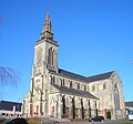
Saint-Jean-Baptiste church

The former Mairie of Le Chefresne


Web links
Individual evidence
- ^ Decree of the Prefecture of Arr. 15-089-VL on the formation of the Commune nouvelle Percy-en-Normandie of December 4, 2015 .
- ↑ current population according to INSEE