
La Meauffe
| La Meauffe | ||
|---|---|---|
.svg)
|
|
|
| region | Normandy | |
| Department | Some | |
| Arrondissement | Saint-Lô | |
| Canton | Pont-Hébert | |
| Community association | Saint-Lô Agglo | |
| Coordinates | 49 ° 11 ′ N , 1 ° 7 ′ W | |
| height | 4–87 m | |
| surface | 10.22 km 2 | |
| Residents | 1,040 (January 1, 2017) | |
| Population density | 102 inhabitants / km 2 | |
| Post Code | 50880 | |
| INSEE code | 50297 | |
| Website | http://pagesperso-orange.fr/mairie.la-meauffe/ | |

La Meauffe is a French commune with 1,040 inhabitants (as of January 1 2017) in the department of Manche in the region of Normandy . The municipality belongs to the canton of Pont-Hébert (until 2015: canton of Saint-Clair-sur-l'Elle ) in the arrondissement of Saint-Lô . The inhabitants are called Meauffois .
geography
La Meauffe is located about seven kilometers north-northwest of Saint-Lô . The river Vire limits the parish to the northwest. La Meauffe is surrounded by the neighboring municipalities of Cavigny in the north and northwest, Airel in the north, Moon-sur-Elle in the north and northeast, Saint-Clair-sur-l'Elle in the northeast, Villiers-Fossard in the east, Le Mesnil-Rouxelin in the South and south-east, Saint-Georges-Montcocq in the south, Rampan in the south-west, Pont-Hébert in the west and south-west.
Population development
| 1962 | 1968 | 1975 | 1982 | 1990 | 1999 | 2006 | 2013 |
| 699 | 723 | 851 | 1,143 | 1,141 | 1,034 | 1,064 | 1,076 |
Culture and sights
- Saint-Martin church, destroyed in 1944, rebuilt after the war
- Remains of the Saint-Gilles castle, destroyed in 1944
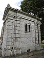
- Lime kiln, Monument historique
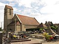
Saint Martin Church
Cemetery chapel

Lime kiln


.jpg)