
Saint-Amand-Villages
| Saint-Amand-Villages | ||
|---|---|---|
|
||
| region | Normandy | |
| Department | Some | |
| Arrondissement | Saint-Lô | |
| Canton | Condé-sur-Vire | |
| Community association | Saint-Lô Agglo | |
| Coordinates | 49 ° 3 ′ N , 0 ° 58 ′ W | |
| height | 43-228 m | |
| surface | 38.19 km 2 | |
| Residents | 2,529 (January 1, 2017) | |
| Population density | 66 inhabitants / km 2 | |
| Post Code | 50160 | |
| INSEE code | 50444 | |

Saint-Amand-Villages is a commune in the French department of Manche in Normandy . It was created as Commune nouvelle with effect from January 1, 2017 by merging the previous municipalities of Placy-Montaigu and Saint-Amand . Saint-Amand-Villages borders
- in the north at Précorbin (commune of Saint-Jean-d'Elle ), Lamberville and Giéville ,
- in the northeast at Le Perron ,
- to the east by Dampierre , to the south-east by Saint-Ouen-des-Besaces and Saint-Martin-des-Besaces (both in the commune of Souleuvre en Bocage ),
- in the south on Guilberville and Giéville , in the southwest on Torigni-sur-Vire (all three in the municipality of Torigny-les-Villes ) and in the west on Condé-sur-Vire ,
- to the northwest at Saint-Jean-des-Baisants (point of contact).
structure
| District | former INSEE code |
Area (km²) | Population as of January 1, 2017 |
|---|---|---|---|
| Placy-Montaigu | 50303 | 8.99 | 237 |
| Saint-Amand (administrative headquarters) | 50444 | 29.20 | 2,292 |
Attractions
- Placy-Montaigu Church
- Saint-Symphorien-les-Buttes church, Monument historique

Placy-Montaigu Church
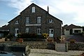
The former Mairie of Placy-Montaigu

Tower of a no longer existing church in Placy-Montaigu

Saint-Symphorien-les-Buttes church


Web links
Commons : Saint-Amand-Villages - Collection of images, videos and audio files
Individual evidence
- ↑ current population according to INSEE