
Saint-Loup-Hors
| Saint-Loup-Hors | ||
|---|---|---|
.svg)
|
|
|
| region | Normandy | |
| Department | Calvados | |
| Arrondissement | Bayeux | |
| Canton | Bayeux | |
| Community association | Bayeux intercom | |
| Coordinates | 49 ° 15 ′ N , 0 ° 43 ′ W | |
| height | 27-82 m | |
| surface | 5.29 km 2 | |
| Residents | 512 (January 1, 2017) | |
| Population density | 97 inhabitants / km 2 | |
| Post Code | 14400 | |
| INSEE code | 14609 | |
| Website | https://www.saint-loup-hors.fr/ | |

Saint-Loup-Hors is a commune with 512 inhabitants (as of January 1, 2017) in Normandy , France . It belongs to the Calvados department , the Bayeux arrondissement and the Bayeux canton . The inhabitants are called Horsais .
geography
Saint-Loup-Hors is about three kilometers southwest of Bayeux city center . Saint-Loup-Hors is surrounded by the neighboring communities of Vaucelles in the north, Bayeux in the north and northeast, Guéron in the east and southeast, Subles in the south and southwest, Ranchy in the west and Barbeville in the northwest.
The National Route 13 runs through the municipality .
Population development
| year | 1962 | 1968 | 1975 | 1982 | 1990 | 1999 | 2006 | 2013 |
|---|---|---|---|---|---|---|---|---|
| Residents | 254 | 244 | 238 | 282 | 293 | 283 | 288 | 400 |
| Source: Cassini and INSEE | ||||||||
Attractions
- Saint-Loup church from the 12th century, monument historique
- Beaussy Castle
- Cambre Castle
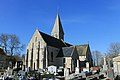
Saint-Loup church
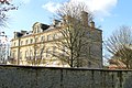
Cambre Castle


literature
- Le Patrimoine des Communes du Calvados. Volume 1, Flohic Editions, Paris 2001, ISBN 2-84234-111-2 , pp. 166-167.
Web links
Commons : Saint-Loup-Hors - Collection of images, videos and audio files