
Mandeville-en-Bessin
| Mandeville-en-Bessin | ||
|---|---|---|
|
||
| region | Normandy | |
| Department | Calvados | |
| Arrondissement | Bayeux | |
| Canton | Trévières | |
| Community association | Isigny-Omaha Intercom | |
| Coordinates | 49 ° 18 ′ N , 0 ° 53 ′ W | |
| height | 4–68 m | |
| surface | 8.83 km 2 | |
| Residents | 336 (January 1, 2017) | |
| Population density | 38 inhabitants / km 2 | |
| Post Code | 14710 | |
| INSEE code | 14397 | |
 Town hall (Mairie) of Mandeville-en-Bessin |
||

Mandeville-en-Bessin is a commune in the department of Calvados in the region of Normandy with 336 inhabitants (as of January 1 2017). Mandeville-en-Bessin belongs to the Arrondissement of Bayeux and the canton of Trévières . The inhabitants are called Mandevillais .
geography
Mandeville-en-Bessin is about 21 kilometers west-northwest of Bayeux . Mandeville-en-Bessin is surrounded by the neighboring communities of Surrain in the north, Mosles in the east, Blay in the south-east, Saon in the south and south-east, Rubercy in the south, Trévières in the west and Formigny La Bataille in the north-west.
Population development
| 1962 | 1968 | 1975 | 1982 | 1990 | 1999 | 2006 | 2013 |
|---|---|---|---|---|---|---|---|
| 433 | 368 | 332 | 305 | 262 | 229 | 274 | 372 |
| Source: Cassini and INSEE | |||||||
Attractions
- Notre-Dame church from the 14th / 15th centuries century
- Saint Martin Church in Tessy
- 16th / 17th century mansion of Douville Century, Monument historique since 1927
- 15th century mansion of Le Quesnay

Notre-Dame church
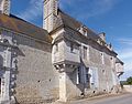
Douville mansion


Web links
Commons : Mandeville-en-Bessin - Collection of images, videos and audio files