La Cambe
| La Cambe | ||
|---|---|---|

|
|
|
| region | Normandy | |
| Department | Calvados | |
| Arrondissement | Bayeux | |
| Canton | Trévières | |
| Community association | Isigny-Omaha Intercom | |
| Coordinates | 49 ° 21 ′ N , 1 ° 0 ′ W | |
| height | 0-39 m | |
| surface | 11.17 km 2 | |
| Residents | 561 (January 1, 2017) | |
| Population density | 50 inhabitants / km 2 | |
| Post Code | 14230 | |
| INSEE code | 14124 | |
| Website | http://www.lacambe.fr/ | |
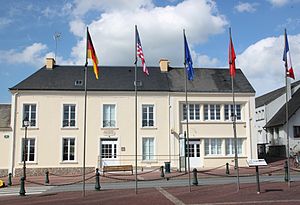
 Town hall (Mairie) of La Cambe |
||
La Cambe is a commune in the department of Calvados in the region of Normandy with 561 inhabitants (as of January 1 2017). La Cambe is part of the Bayeux arrondissement and the Trévières canton .
geography
La Cambe is about 30 kilometers west-northwest of Bayeux . La Cambe is surrounded by the neighboring communities of Grandcamp-Maisy in the north and north-west, Cricqueville-en-Bessin in the north, Saint-Pierre-du-Mont in the north-east, Deux-Jumeaux in the east and north-east, Canchy in the east, Colombières in the south-east, Monfréville in the south and south-west, Saint-Germain-du-Pert in the west and south-west, Cardonville in the west and Géfosse-Fontenay in the north-west.
The National Route 13 runs through the municipality .
Population development
| 1962 | 1968 | 1975 | 1982 | 1990 | 1999 | 2006 | 2013 |
|---|---|---|---|---|---|---|---|
| 730 | 615 | 540 | 552 | 588 | 518 | 609 | 628 |
| Source: Cassini and INSEE | |||||||
Attractions
- Notre-Dame church
- Chapel of Saint-Roch of the Château de Jucoville
- German military cemetery from World War II
Web links
Commons : La Cambe - collection of images, videos and audio files
