Vännäsby
| Vännäsby | ||||
|
||||
| State : | Sweden | |||
| Province (län): | Västerbotten County | |||
| Historical Province (landskap): | Västerbotten | |||
| Municipality : | Vännäs | |||
| Coordinates : | 63 ° 55 ' N , 19 ° 49' E | |||
| SCB code : | 8388 | |||
| Status: | Crime scene | |||
| Residents : | 1581 (December 31, 2015) | |||
| Area : | 2.05 km² | |||
| Population density : | 771 inhabitants / km² | |||
| List of perpetrators in Västerbotten County | ||||
Vännäsby is a place ( Tatort ) in the Swedish province of Västerbotten County and in the historic province of Västerbotten .
location
Vännäsby belongs to the municipality of Vännäs . The place is about 25 km as the crow flies northwest of the provincial capital Umeå and three kilometers east of the main town of the municipality, Vännäs , on the left bank of the 200 meter wide Ume älv . Immediately on the eastern edge of the village, the equally large Vindelälven, the largest tributary of the Ume älv, flows in from the left. Vännäsby is the second largest town after Vännäs and one of the municipality's two crime scenes.
The place is on the railway line that branches off in Vännäs from the Stambanan genom övre Norrland (Nordlandbahn) and leads to Umeå. The line called Umeåbanan was opened to Umeå in 1896 and extended to Holmsund and the port of Umeå on the Baltic Sea in 1920 .
Vännäsby is bypassed north of the European route 12 , the blue route , which leads on its Swedish section from Umeå via Storuman to the winter sports resort Tärnaby and on to Mo i Rana in Norway . The national road 92 branches off between Vännäsby and Vännäs , a cross connection via Åsele to Dorotea on Inlandsvägen , the European route 45 .
history
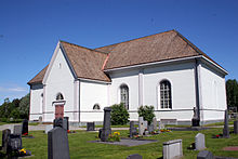
The origins of today's Vännäs lie in Vännäsby. The place was initially called Wendenäs. The Vännäs kyrka was built there between 1816 and 1825 . The church, which was last restored in 1967, is now one of the local attractions.
After the construction of the Nordland Railway at the end of the 19th century, the center of the village moved to the new settlement around the Vännäs train station, a few kilometers to the west, which is now Vännäs. The train station at today's Vännäsby, on the other hand, was named Spöland in 1899 after the small settlements Västra and Östra Spöland located a few kilometers north on both banks of the Vindelälven . The name Vännäsby has been in use since 1940.
Today Vännäsby is in fact a suburb of the Vännäs community center. In Vännäsby there is a large industrial area due to the favorable traffic situation.
Individual evidence
- ↑ a b Statistiska centralbyrån : Land area per Tatort, folkmängd and invånare per square kilometer. Vart femte år 1960 - 2015 (database query)
- ↑ Vännäs kyrka on the website of the Church of Sweden (Swedish)

