Vallée du Trient
| Vallée du Trient | ||
|---|---|---|
|
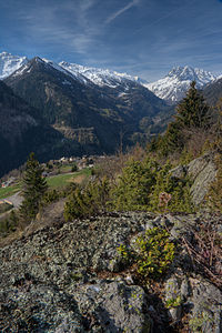
View of Finhaut in the Vallée du Trient |
||
| location | Switzerland / Valais | |
| Waters | Trent | |
| Mountains | Valais Alps | |
| Geographical location | 565 897 / 100704 | |
|
|
||
The Vallée du Trient or Val de Trient is a valley in the canton of Valais in Switzerland . It is on the left bank of the Rhone . It owes its name to the mountain stream Trient , which rises from the Trient glacier . The valley joins the Rhone Valley shortly after Martigny .
Shortly before the end of the valley, the Trient flows through the 200-meter-deep Gorge du Trient (Trient Gorge), which can be climbed via paved trails. The gorge is spanned by the Pont de Gueuroz bridge.
The valley is about 17 kilometers long.
traffic
There is no road through the valley that can be used continuously. The road of Col de la Forclaz runs through the middle of the valley . The lower part is served by the Martigny – Chamonix railway line . There is also a road from the Rhone Valley to Salvan and Les Marécottes .
Municipalities and localities
The following villages are in the valley:
- Trent
- Finhaut
- Vernayaz
- Le Trétien
- Les Marécottes
- Salvan
Reservoirs
The two reservoirs Lac du Vieux Emosson and Lac d'Emosson lie high above the valley . They can be reached via three lifts, the VerticAlps. Well-preserved archosaur footprints have been discovered near Lac du Vieux Emosson .

