Valli di Comacchio
| Valli di Comacchio | |
|---|---|

|
|
| Comacchio saltworks | |
| Geographical location | Italy ( Emilia-Romagna , Province of Ferrara , Province of Ravenna ) |
| Tributaries | Reno |
| Drain | Portocanale , Logonovo , Gobbino |
| Places on the shore | Comacchio , Sant'Alberto , Lido degli Estensi , Lido di Spina , Porto Garibaldi |
| Data | |
| Coordinates | 44 ° 37 ′ 0 ″ N , 12 ° 11 ′ 0 ″ E |
| Altitude above sea level | 0 m |
| surface | 115 km² |
| Maximum depth | 1.5 |
| Middle deep | 1 m |
The Valli di Comacchio ( Valli residue del comprensorio di Comacchio ) are a lagoon landscape in the northern Italian region of Emilia-Romagna on the border of the provinces of Ferrara and Ravenna in the area of the municipalities of Comacchio , Argenta and Ravenna . The area belongs to the Parco regional del Delta del Po, recognized by UNESCO as a World Heritage Site . It was included in the list of wetlands worth protecting as part of the Ramsar Convention and is designated as a European bird sanctuary .
The Valli di Comacchio are the largest of a series of lagoon lakes that lie between the Po Delta and Ravenna . Worth mentioning is the Valle Bertuzzi near Lido di Volano , which has a similarly rich fauna and flora.
description
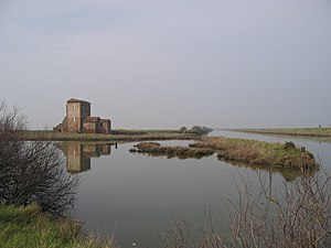
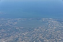
The Valli di Comacchio consist of a central lagoon, richly structured by islands and dams, and adjacent wetlands. In the south the area is bounded by the course of the Reno river , in the north by the city of Comacchio , which was once built on lagoon islands , similar to Venice , Chioggia and Caorle . To the east, the lagoon is separated from the Adriatic Sea by a 2–3 km wide strip of land , with which it is connected by three channels - Portocanalo, Logonovo and Gobbino. In the west, the original wetlands gradually change into agricultural areas drained by numerous canals, which were drained in the 19th century as part of land reclamation projects, so that the original extent of the Valli di Comacchio was reduced from approx. 730 km² to today's 115 km². Even so, they are still among the largest wetlands in Italy. The lagoon receives fresh water supply primarily from the spring floods of the Reno and from precipitation. Due to the tides, salt water enters the lagoon via the connections to the Mediterranean, so that it is filled with brackish water.
In Sant'Alberto on the southern edge of the lagoon there is an information center about the reserve. Guided excursions into the lagoon are offered here, which also open up otherwise inaccessible regions.
Emergence
The Valli di Comacchio were created in the tenth century by the gradual subsidence of the coastal zone. The area was initially flooded by fresh water from the Reno. In the 16th century, as a result of the increasing water exchange with the Mediterranean, which was also promoted by structural measures, today's brackish water lagoon was created.
designation
The current division of the lagoon into isolable sub-basins - the most important are the Valle Lido di Magnavacca, the Valle Fossa di Porto, the Valle Campo and the Valle Fattibello - arose from the use of the lagoon for fishing since the 16th century. Protected sub-basins were isolated in order to optimize the rearing and catching of fish and to be able to control the water quality. These basins - analogous to the Valli da Pesca of the Venetian lagoon - were derived from the Latin Vallum, protective wall, called Valli.
flora
The flora of the Valli di Comacchio is characterized by its adaptation to the salty brackish water. Salt-resistant reeds and grasses such as swaths of salt as well as samphire and tamarisk dominate the banks and islands of the lagoon. Even salt herbs and Ruppia cirrhosa can be found.
fauna
The lagoon's fish population includes eel , sea bass , sole , red mullet , bream and flounder . The Valli di Comacchio are home to over 300 species of birds, including flamingos , stilts , silk , purple and gray herons, as well as ruff and plover . Many species of migratory birds, especially numerous species of ducks, take up residence here. Birds of prey nesting in the area include falcons and harriers .
use
The Valli di Comacchio are a cultural landscape formed by diverse uses by humans. In the northeast, at the height of Lido degli Estensi , the Comacchio salt flats occupy a large area. Salt production was only stopped in 1984 due to a lack of profitability. Fishing and fish farming, as well as mussel farming, still play an important role today. Marinated eel in particular is one of the region's traditional products. Specially constructed fish tanks, so-called lavorieri, were created for rearing and catching eels. The fishermen's houses on stilts with the nets stretched over the water shape the banks of the lagoon and especially the canals. Porto Garibaldi is an important fishing port.
The strip of land between the lagoon and the sea is now largely used for tourism. Towards the sea are the beaches of the seaside resorts of Porto Garibaldi, Lido degli Estensi and Lido di Spina, which are part of the Lidi di Comacchio .
The Roman ship
In 1980 a Roman riverboat was found near the Valle Ponti, a part of the lagoon near Comacchio that was drained between 1919 and 1921, and was excavated in 1981. The ship is dated to the end of the first century BC. It was supposed to be supposed to transport goods up the Po from an Adriatic port, but it was damaged in the river estuary at that time. The wreck was covered by sand very quickly, which explains the good state of preservation of the excavations. These are exhibited today in the specially established Museo della Nave Romana in Comacchio.
Photographic impressions
Individual evidence
- ↑ Ferrara, City of the Renaissance, and its Po Delta ( English ) UNESCO . 1999. Retrieved September 4, 2011.
- ^ The Annotated Ramsar List: Italy ( English ) Ramsar Secretariat. September 27, 2010. Retrieved September 4, 2011.
- ^ Siti di importanza comunitaria e zone di protezione speciale ( Italian ) Emilia-Romagna regional administration. Retrieved February 7, 2020.
- ^ MV Mikhailova: The Hydrological Regime and the Pecularities of Formation of the Po River Delta ( English ) Springer. Retrieved September 4, 2011.
- ^ Valli da pesca ( Italian ) Istituto Veneto Di Scienze. Retrieved February 7, 2020.
- ↑ Fede Berti: The Comacchio Wreck ( English ) Navis. Retrieved September 5, 2011.
Web links
- Official website (Italian)
- Valli di Comacchio at www.parks.it (Italian)


