Landstuhl Association (1971–2019)
| coat of arms | Germany map | |
|---|---|---|

|
Coordinates: 49 ° 25 ' N , 7 ° 34' E |
|
| Basic data (as of 2019) | ||
| State : | Rhineland-Palatinate | |
| County : | Kaiserslautern | |
| Area : | 56.12 km 2 | |
| Residents: | 15,269 (Dec. 31, 2018) | |
| Population density : | 272 inhabitants per km 2 | |
| License plate : | KL | |
| Association key : | 07 3 35 5005 | |
| Association structure: | 6 municipalities | |
| Location of the Landstuhl Association in the Kaiserslautern district | ||
The Verbandsgemeinde Landstuhl was an administrative unit in the legal form of a regional body in the district of Kaiserslautern in Rhineland-Palatinate . The municipality of the association included the town of Landstuhl and five independent local communities , the administrative seat was in the eponymous town of Landstuhl. On July 1, 2019, the merger with the Kaiserslautern-Süd community took place to form the new Landstuhl community .
Association members communities
| Local parish, city | Area (km²) | Residents |
|---|---|---|
| spell | 12.94 | 2,294 |
| Main chair | 5.00 | 1,214 |
| Kindsbach | 8.80 | 2,492 |
| Landstuhl , city | 15.34 | 8,870 |
| Mittelbrunn | 8.97 | 744 |
| Oberarnbach | 5.08 | 434 |
| Landstuhl Association | 56.14 | 16,048 |
(Residents on May 30, 2018)
Population development
The development of the number of inhabitants in relation to the area of the Landstuhl Association at the time of its dissolution; the values from 1871 to 1987 are based on censuses :
|
|
politics
Association municipal council
The last Verbandsgemeinderat Landstuhl consisted of 32 honorary council members, who were elected in a personalized proportional representation in the local elections on May 25, 2014 , and the full-time mayor as chairman. Their term of office ended on June 30, 2019 by state law.
The distribution of seats in the former municipal council:
| choice | SPD | CDU | FDP | FWG | total |
|---|---|---|---|---|---|
| 2014 | 11 | 15th | - | 6th | 32 seats |
| 2009 | 9 | 16 | 3 | 4th | 32 seats |
| 2004 | 8th | 19th | 1 | 4th | 32 seats |
- FWG = Free Voting Group Verbandsgemeinde Landstuhl eV
coat of arms
|
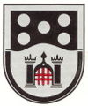
Blazon : "In a shield border divided by silver and black, divided by black and silver in a wave shape, above five silver bolls 2: 1: 2, below a black gate system with two tin towers and a closed red portcullis."
The coat of arms was approved by the Neustadt district government in 1979 . |
|
| Justification for the coat of arms: The Bollen reminds of the Lords of Sickingen , to whose domain all communities used to belong. |
Individual evidence
- ↑ a b Population on May 31, 2018. City of Landstuhl , accessed on August 5, 2018 .
- ↑ Population on December 31, 2016. City of Landstuhl , accessed on July 22, 2017 .
- ↑ Population on December 31, 2017. Stadt Landstuhl , accessed on January 17, 2018 .
- ^ State of Rhineland-Palatinate: State law on the merger. Section 2 (1) November 27, 2015, accessed on August 17, 2019 .
- ↑ The Regional Returning Officer Rhineland-Palatinate: Municipal elections 2014, Verbandsgemeinderatswahlen
- ^ Karl Heinz Debus: The great book of arms of the Palatinate. Neustadt an der Weinstrasse 1988, ISBN 3-9801574-2-3 .


