
Verbandsgemeinde Weida-Land
| coat of arms | Germany map | |
|---|---|---|
 Help on coat of arms |
Coordinates: 51 ° 22 ′ N , 11 ° 40 ′ E |
|
| Basic data | ||
| State : | Saxony-Anhalt | |
| County : | Saalekreis | |
| Area : | 136.49 km 2 | |
| Residents: | 7766 (Dec. 31, 2019) | |
| Population density : | 57 inhabitants per km 2 | |
| License plate : | SK, MER, MQ, QFT | |
| Association key : | 15 0 88 5051 | |
| Association structure: | 6 municipalities | |
| Association administration address : |
Hauptstrasse 43 06268 Nemsdorf-Göhrendorf |
|
| Website : | ||
| Verbandsgemeinde- mayor: |
Kay-Uwe Böttcher ( CDU ) | |
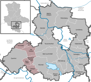
| Location of the community of Weida-Land in the Saalekreis | ||
  |
||

The Verbandsgemeinde Weida-Land is a regional authority in the Saalekreis in Saxony-Anhalt . The Verbandsgemeinde came into being on January 1st, 2010. Since Verbandsgemeinde may have a maximum of eight member municipalities with at least 1000 inhabitants each, the following changes took place on January 1st, 2010:
- Merger of the municipalities of Albersroda (459 inhabitants) and Steigra (870 inhabitants) to form the new municipality of Steigra (1,329 inhabitants)
- Incorporation of the municipality of Alberstedt (467 inhabitants) into the municipality of Farnstädt , whose population increases from 1,181 to 1,648
- Incorporation of the community Esperstedt (646 inhabitants) into the community Obhausen , whose population increases from 1,811 to 2,457
The specified population figures refer to the key date December 31, 2008.
geography
The eponymous Weida flows through the municipality .
Member municipalities
The following six member municipalities belong to the Weida-Land association:
traffic
The federal autobahn 38 and the federal highway 180 run through the municipality . There is a train station in Nemsdorf-Göhrendorf.