
Vermelho Velho
| Distrito de Vermelho Velho Vermelho Velho |
|||
|---|---|---|---|
 View of Vermelho Velho
|
|||
|
|||
| Coordinates | 19 ° 59 ′ S , 42 ° 20 ′ W | ||

|
|||
| Basic data | |||
| Country | Brazil | ||
| State | Minas Gerais | ||
| city | Raul Soares | ||
| ISO 3166-2 | BR-MG | ||
| height | 468 m | ||
| Time zone | UTC −3 | ||

Vermelho Velho , officially Distrito de Vermelho Velho , is one of six districts of the Raul Soares municipality in Minas Gerais , Brazil . The settlement of the same name Vila de Vermelho Velho is the seat of the district. In 2000 there were 2,625 residents ( IBGE / 2000) who are called Vermelhenser. As a district, it has no right of self-government.
geography
The district is located in the biome of the Mata Atlântica at an altitude of 468 meters above sea level and is mountainous. The humid subtropical climate with monsoon influences is classified as Cwa according to Köppen and Geiger . It is about 220 km from the capital Belo Horizonte and is crossed by the state road MG-329 with connection in Caratinga to the federal road BR-116 . Economically, the area is integrated into the micro-region Ponte Nova , which belongs to Raul Soares . Agricultural products are rice, corn, coffee, cassava and sugar cane.
history
The country was the traditional settlement area of the botocuds (aimorés) in Minas Gerais. After armed conflicts at the beginning of the 19th century, the first settlement by white people took place around 1830. The place name Vermelho, German red , is derived from the hue of a small river and the ground, the district founded on May 23, 1856 was called Distrito de Ribeirão Vermelho (Red Brook District). The Ribeirão Vermelho runs north of the settlement. The territory was administered successively by the municipalities of Manhuaçu , Ponte Nova , Caratinga (1890), Bom Jesus do Galho and Raul Soares (from 1924), the area was about 113 km², 12 km away Vermelho Novo ("New Vermelho") ) on December 21, 1995 spun off and independent, while the "old Vermelho" remained with Raul Soares. In 1930 there was a connection to the Linha de Manhuaçu railway of the Estrada de Ferro Leopoldina . The seat of the district had a population of 635 inhabitants in 1950, in the 2000 census there were 2,625 inhabitants, but the majority of the remaining part of the district population is spread over the rural area.
The main town is the seat of the Catholic parish of São Francisco de Assis , which was established on November 18, 1865 and belongs to the Caratinga diocese . In 1946 a Presbyterian church was added. In total there are 11 other small settlements (povoados) with their own chapel in the area of Vermelho Velho .

State Primary School Albano Pires
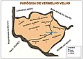
Settlements with churches in Vermelho Velho

Main Church of São Francisco de Assis


Sons and daughters
- José Zeferino Pires (1904–?), City Prefect of Raul Soares and MP in Minas Gerais
Web links
- Map Raul Soares with Vermelho Velho: Instituto Brasileiro de Geografia e Estatística : Enciclopédia dos municípios brasileiros - Volume VII: Grande Região Leste. Rio de Janeiro 1960, p. 247 [Fig. 249]. (PDF; 133.7 MB; accessed May 16, 2017, Brazilian Portuguese).
Individual evidence
- ↑ IBGE : Cidades @ Minas Gerais: Raul Soares. História. Retrieved September 19, 2019 (Brazilian Portuguese).
- ↑ Raul Soares. In: Instituto Brasileiro de Geografia e Estatística: Enciclopédia dos municípios brasileiros - Volume XXVII: Municípios do Estado de Minas Gerais. Rio de Janeiro 1959, pp. 13-16. (PDF; 85.2 MB; accessed May 16, 2017, Brazilian Portuguese).