
Administrative community Rothenburg / Oberlausitz
| coat of arms | Germany map | |
|---|---|---|
 Help on coat of arms |
Coordinates: 51 ° 20 ' N , 14 ° 58' E |
|
| Basic data | ||
| Existing period: | 1994– | |
| State : | Saxony | |
| Headquarters: | Dresden | |
| County : | Goerlitz | |
| Area : | 122.17 km 2 | |
| Residents: | 5705 (Dec. 31, 2019) | |
| Population density : | 47 inhabitants per km 2 | |
| License plate : | GR, LÖB, NOL, NY, WSW, ZI | |
| Association key : | 14 6 26 5 235 | |
| Association structure: | 2 municipalities | |
| Association administration address : |
Marktplatz 1 02929 Rothenburg / Oberlausitz |
|
| Website : | ||
| Association chair: | Heike Boehm | |
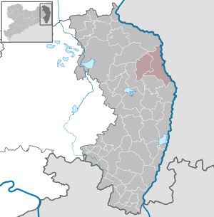
| Location of the administrative community Rothenburg / Oberlausitz in the district of Görlitz | ||
  |
||

The administrative community Rothenburg / Oberlausitz (officially administrative community Rothenburg / OL ) is a Saxon administrative community in the district of Görlitz . It is located in the northeast of the district, around 25 km north of the district town of Görlitz and around 13 km east of the city of Niesky . In the east, the administrative area borders on Poland with the Lausitzer Neisse . The landscape is characterized by extensive forests. The city of Rothenburg was known in GDR times for the nearby Rothenburg / Görlitz airfield .
The municipalities with their districts
- Rothenburg / Oberlausitz with the districts Stadt Rothenburg with Noes and Bleiche, Steinbach, Lodenau, Neusorge, Bremenhain, Dunkelhäuser, Geheege, Nieder-Neundorf and Uhsmannsdorf
- Hähnichen with the districts of Hähnichen, Quolsdorf, Spree and Trebus