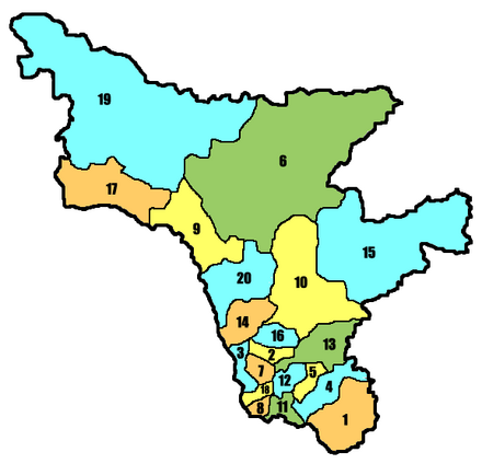
Administrative division of Amur Oblast
The Amur Oblast in the Far East of Russia is divided into 20 Rajons and 9 urban districts .
City districts
| Urban district | Residents | Area (km²) |
Population density (inh / km²) |
Urban population |
Rural population |
More places |
|---|---|---|---|---|---|---|
| Belogorsk | 68,245 | 136 | 502 | 67,767 | 478 | |
| Blagoveshchensk | 212,548 | 323 | 658 | 207,333 | 5,215 | |
| progress | 12,978 | ? | 12,978 | - | ||
| Raichichinsk | 24,460 | 377 | 65 | 24,408 | 52 | |
| Shimanovsk | 21,923 | 50 | 438 | 21,923 | - | Novoraichichinsk |
| Seja | 26,995 | 40 | 675 | 26,995 | - | |
| Svobodny | 60,034 | 226 | 266 | 60,034 | - | |
| Tynda | 38,216 | 125 | 306 | 38,216 | - | |
| Uglegorsk ( Tsiolkovsky ) | 5,273 | ? | 5,273 | - |
Rajons
| Rajon | Residents | Area (km²) |
Population density (inh / km²) |
Urban population |
Rural population |
Administrative headquarters | More places |
|---|---|---|---|---|---|---|---|
| Archara (1) | 18,743 | 14,450 | 1.3 | 9,836 | 8,907 | Archara | |
| Belogorsk (2) | 22,985 | 2,680 | 8.6 | - | 22,985 | Belogorsk | |
| Blagoveshchensk (3) | 18,634 | 3,070 | 6.1 | - | 18,634 | Blagoveshchensk | |
| Bureja (4) | 28,674 | 7,330 | 3.9 | 21,778 | 6,896 | Novobureiski | Bureja , Talakan |
| Ivanovka (7) | 30.501 | 2,610 | 11.7 | - | 30.501 | Ivanovka | |
| Konstantinovka (8) | 14,716 | 1,770 | 8.3 | - | 14,716 | Konstantinovka | |
| Magdagachi (9) | 24,095 | 16,790 | 1.4 | 16,037 | 8,058 | Magdagachi | Siwaki , Ushumun |
| Masanovo (10) | 15,103 | 27,970 | 0.5 | - | 15,103 | Novokievsky Uwal | |
| Mikhailovka (11) | 16,490 | 2,990 | 5.5 | - | 16,490 | Pojarkowo | |
| Oktyabrsky (12) | 23,025 | 3,430 | 6.7 | - | 23,025 | Ekaterinoslavka | |
| Romny (13) | 10,658 | 9,990} | 1.1 | - | 10,658 | Romny | |
| Savitinsk (5) | 18,408 | 3,240 | 5.7 | 12,993 | 5,415 | Savitinsk | |
| Shimanovsk (20) | 6,965 | 14,630 | 0.5 | - | 6,965 | Shimanovsk | |
| Seja (6) | 20,237 | 88,260 | 0.2 | - | 20,237 | Seja | |
| Selemjinsky (15) | 11,365 | 46,810 | 0.2 | 9,733 | 1,632 | Ekimchan | Fevralsk , Koboldo , Ogodscha , Tokur |
| Seryshevo (16) | 28,170 | 3,830 | 7.4 | 11,935 | 16,235 | Seryshevo | |
| Skovorodino (17) | 32,266 | 18,020 | 1.8 | 19,430 | 12,836 | Skovorodino | Erofei Pavlovich , Urusha |
| Svobodny (14) | 13,535 | 7,420 | 1.8 | - | 13,535 | Svobodny | |
| Tambovka (18) | 25,437 | 2,560 | 9.9 | - | 25,437 | Tambovka | |
| Tynda (19) | 16,057 | 84,300 | 0.2 | - | 16,057 | Tynda |
Remarks:
- ↑ a b Population figures from January 1, 2008 (calculation)
- ↑ Closed City (SATO)
- ↑ in brackets number of the Rajon on the map (in alphabetical order of the Rajon names in Russian)
- ↑ a b c d e f City does not belong to the Rajon, but forms an independent city district; Population of the city not included in the calculation of population density
swell
- Overview of the administrative structure on the official website of the Amur Oblast Administration (Russian)
- Amur Oblast on terrus.ru (Russian)
