Villgratenbach
|
Villgratenbach Arntalbach (upper course), Stallerbach (middle course) |
||
|
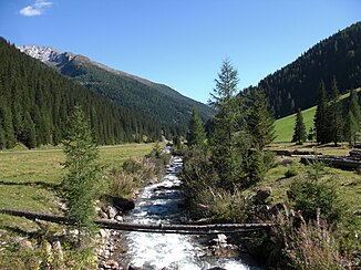
The Stallerbach at the Unterstalleralm |
||
| Data | ||
| Water code | AT : 2-374-16 | |
| location | East Tyrol | |
| River system | Outside | |
| Drain over | Drau → Danube → Black Sea | |
| source | in the Villgraten mountains 46 ° 51 ′ 15 ″ N , 12 ° 23 ′ 39 ″ E |
|
| Source height | 2418 m above sea level A. | |
| muzzle | near Panzendorf in the Drau coordinates: 46 ° 44 ′ 46 ″ N , 12 ° 26 ′ 40 ″ E 46 ° 44 ′ 46 ″ N , 12 ° 26 ′ 40 ″ E |
|
| Mouth height | 1072 m above sea level A. | |
| Height difference | 1346 m | |
| Bottom slope | 54 ‰ | |
| length | 24.7 km | |
| Catchment area | 176.9 km² | |
| Discharge at the Eggeberg A Eo gauge : 35.2 km² Location: 13 km above the mouth |
NNQ (03/14/1996) MQ 1991–2010 Mq 1991–2010 MHQ 1991–2010 HHQ (11/01/2004) |
190 l / s 990 l / s 28.1 l / (s km²) 6.28 m³ / s 14.7 m³ / s |
| Left tributaries | Winkeltalbach | |
| Right tributaries | Kalksteinerbach | |
| Communities | Innervillgraten , Auservillgraten , Heinfels | |
|
Villgratenbach |
||
The Villgratenbach , also Villgraterbach , is a left tributary of the Drau in East Tyrol .
geography
Run and landscape
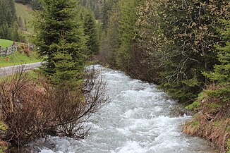
The Villgratenbach is almost 25 km long. It rises as Arntalbach in the Villgraten mountains at an altitude of 2418 m above sea level. A. It initially flows in a westerly direction through the Arntal . In the area of Oberstaller- and Unterstalleralm, where it is also called Stallerbach , it turns to the south and then flows through the Villgratental with the communities of Innervillgraten and Auservillgraten . At Panzendorf (municipality of Heinfels ) the Villgratenbach finally flows into the Drau after overcoming around 1350 meters of altitude. The historic Punbrugge crosses the brook below Heinfels Castle .
geology
The Villgratenbach flows through a relatively uniform hydrogeological formation of crystalline slates . Granite and gneiss also occur only in the area of origin . The Villgratenbach usually flows through narrow notch valleys ; only in the estuary area and at Innervillgraten do valley widenings occur, overlaid by gravel and sand . In the lower reaches, however, the Villgratenbach runs in gorges .
environment
fauna and Flora
The predominant vegetation along the Villgratenbach is coniferous forests . The only exceptions are the agriculturally used valley lowlands with the main towns and the leveling sections in the lower reaches and the estuary. In some cases, azonal woody stands have developed near the shore, but there are no larger alluvial forest systems because potential locations are used by humans.
Bank condition and building measures
The course of the Villgratenbach has been greatly altered by man, and now only has a few sections of the route that have not been or only slightly influenced. These include Verebnungsbereiche in the upper reaches, canyon sections at the entrance to to Außervillgraten and the gorge path near the mouth of limestone creek . In the rest of the route, the Villgratenbach is particularly influenced by the routing of the state road near the banks and by the pressure of the settlement in the valley widening. In Panzendorf, dam structures and block stone barriers secure the settlement, while in Ausservillgraten the banks are fortified by bank masonry. In addition, the Villgratenbach near Innervillgraten and the Stalleralm were straightened with barriers to secure areas or banks.
Water quality
The water quality of Villgratenbaches achieved throughout the course of the water quality class I-II (uncontaminated to moderate). Only in the area of the main towns, Ausservillgraten and Innervillgraten, is the water quality reduced due to increased discharge of wastewater, with wastewater plumes up to three kilometers below the town center.
Economic use
The lower reaches of the Villgratenbach is used for energy purposes. Of the two existing power plant buildings, however, the outdated part of the power plant near Ronebach has already been abandoned. The diversion to the TIWAG power plant is located shortly before Ausservillgraten, the return is in the area of the EGO plant near Panzendorf. The remaining water distance is 3.6 kilometers, with 60% of the total amount of water remaining as residual water. In addition to the power plant discharge, there are also temporarily operated discharge lines for two mills and a sawmill . However, the residual water quantity is more than 95% in all three cases.
literature
- Office of the Tyrolean Provincial Government, Dept. Environmental Protection (Ed.): Nature Conservation Plan for the Tyrolean Rivers. Classification of the river area-specific natural area potential. District: East Tyrol. Lienz 2004 ( PDF; 662 kB )
Individual evidence
- ↑ a b c TIRIS - Tyrolean regional planning and information system
- ↑ Federal Ministry of Agriculture, Forestry, Environment and Water Management (Ed.): Area directory of the Austrian river basins: Draugebiet. Contributions to the hydrography of Austria, issue No. 59, Vienna 2011, p. 3 ( PDF; 3.5 MB )
- ↑ Federal Ministry of Agriculture, Forestry, Environment and Water Management (ed.): Hydrographisches Jahrbuch von Österreich 2010. 118th volume. Vienna 2012, p. OG 321, PDF (12.6 MB) on bmlrt.gv.at (yearbook 2010)

