Vlattener Bach
| Vlattener Bach | ||
|
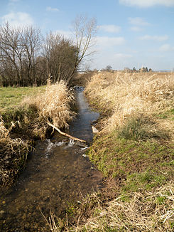
Vlattener Bach between Floren and Lövenich |
||
| Data | ||
| Water code | DE : 27446 | |
| location | North Rhine-Westphalia , Germany | |
| River system | Rhine | |
| Drain over | Rotbach → Erft → Rhine → North Sea | |
| source | On the eastern slope of the Kermeter , east-southeast of the village of Wolfgarten 50 ° 35 ′ 34 ″ N , 6 ° 30 ′ 13 ″ E |
|
| Source height | 483 m above sea level NN | |
| muzzle | In Lövenich (Zülpich) in the Rotbach coordinates: 50 ° 40 ′ 22 ″ N , 6 ° 40 ′ 20 ″ E 50 ° 40 ′ 22 ″ N , 6 ° 40 ′ 20 ″ E |
|
| Mouth height | 161 m above sea level NN | |
| Height difference | 322 m | |
| Bottom slope | 15 ‰ | |
| length | 21.8 km | |
| Catchment area | 31.528 km² | |
The Vlattener Bach is an orographically right-hand, 21.8 km long tributary of the Rotbach (tributary of the Erft ), on the northern edge of the Eifel . It gets its name from the place Vlatten , which it flows through.
course
The source of the Vlattener Bach is on the eastern slope of the Kermeter , east-southeast of the village of Wolfgarten . It flows through Hergarten , Vlatten (both town of Heimbach ) and Wollersheim (town of Nideggen ), and flows north past Eppenich and Bürvenich , on through Merzenich and Floren and then flows into the Rotbach in Lövenich (all towns of Zülpich ).
Attractions
- the St. Dionysius Church in Vlatten
- the upper castle of Vlatten
Individual evidence
- ↑ a b German basic map 1: 5000
- ↑ a b Topographical Information Management, Cologne District Government, Department GEObasis NRW ( information ) (query on November 11, 2010)
