Vlie
The Vlie or the Vliestroom is a Dutch sea arm in the Wadden Sea between the West Frisian Islands Vlieland in the southwest and Terschelling in the northeast.
history
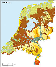
Today the Vlie denotes the sea channel in the Wadden Sea, but in the early Middle Ages the sea area looked very different. Around 800 AD, before the creation of the Zuidersee , the Vlie joined the Wadden Sea of the North Sea as a navigable, narrow arm of the sea with the inland lake Almere , a forerunner of the Zuidersee. The IJssel drained into the North Sea via both .
The devastating storm surges of the Middle Ages such as the Julian flood of 1164, the All Saints Flood of 1170 and finally the First Marcellus Flood of 1219 broke into the area, and the inland waters of Almere became a large bay with the Zuidersee .
Historical meaning
In the early Middle Ages, the Vlie was the historical border between the historical West Friesland landscape on the mainland in what is now the province of Noord-Holland and the province of Friesland . This goes back to the Great Frisian Empire , which was in conflict with the Franconian Empire . The Frisians under their king Radbod lost 690 AD in the battle of Wijk bij Duurstede and had to cede the part west of the Vlie to the Franks . Although the Frisians were able to briefly recapture the areas in 716 AD, they had to surrender this and other areas to the Franks after the Battle of the Boorne in 734 AD.
The historical boundary of the Vlie can also be seen in the Lex Frisionum , one of the oldest legal texts of the Frisians. The Lex Frisionum applied to almost all of Friesland . However, different regions were distinguished in it. It specifically applied to the central part of Friesland (roughly the area of today's province of Friesland in the Netherlands). Different rules were made in some places for two neighboring areas:
- the area between the Zwin and Vlie rivers (in the south of the Netherlands and in the north of Belgium ) and
- the area between the rivers Lauwers and Weser , i.e. roughly the area of today's Dutch province of Groningen and East Friesland in north-west Germany .
This shows a very early historical subdivision of the Frisian areas into a heartland and neighboring areas.
See also
- The Lauwers has a similar historical significance.
Coordinates: 53 ° 19 '54.1 " N , 5 ° 8' 29.8" E
