Wülfrather Kalkgebiet
| Wülfrather Kalkgebiet | |||
|---|---|---|---|
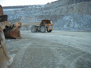
| Lime extraction in Wülfrath | |||
| Systematics according to | Handbook of the natural spatial structure of Germany | ||
| Greater region 1st order | Low mountain range threshold | ||
| Greater region 2nd order | Rhenish Slate Mountains | ||
| Main unit group | 33 → Süderbergland |
||
| About main unit | 337 → Bergisch-Sauerland lowlands |
||
| 4th order region (main unit) |
337 1 → Niederbergisch-Märkisches hill country |
||
| 5th order region | 337 1 .1 → Bergisch-Märkisches hill country |
||
| Natural space |
337 1 .17 → Wülfrath limestone area |
||
| Geographical location | |||
| Coordinates | 51 ° 17 ′ 0 ″ N , 7 ° 2 ′ 0 ″ E | ||
|
|||
| local community | Wuelfrath | ||
| state | North Rhine-Westphalia | ||
| Country | Germany | ||
The Wülfrath limestone area is a fragmented natural spatial unit with the order number 337 1 .17 in the area of the Bergisch town of Wülfrath .
The narrow, loess-covered depression at a height of 200 m consists of light, strongly folded, thick-banked to massive Upper Devonian mass limestone ( Dorper Kalk , Iberger Kalk ). The limestone ridges unfolded in the limestone area are called Wülfrather Sattel , Rodenhauser Sattel and Rützkauser Sattel . The depression lies in the western roof of the Velberter Höhenrücken (order number 337 1 .10) and is surrounded by significantly greater heights in the north, east and south. Only in the west is the transition to the Mettmanner Loessterrassen (order number 337 1 .00) barely noticeable.
The loess soils lie on a heavily karstified surface in which numerous sinkholes filled with Miocene sands and deep carts can be found. Dry valleys in the interior and stream shrinkage at the edges also characterize the natural area.
In the Wülfrather limestone region of the center of the city Wülfrath, the numerous large-scale, mainly by the company is Rheinkalk actively managed or been abandoned limestone quarries (quarry near Schlupkothen , Bochum break , pit Emanuel , Fortuna mine , quarry Rohdenhaus , quarry Prangenberg House ) is surrounded. Industrial lime mining in open-cast mines is the most important branch of the economy in Wülfrath, while the Flandersbach Rhine lime plant with the Rohdenhaus quarry is the largest in Europe.

