Wüllersleben
|
Wüllersleben
Community Bösleben-Wüllersleben
Coordinates: 50 ° 48 ′ 54 ″ N , 11 ° 4 ′ 7 ″ E
|
|
|---|---|
| Height : | 394 (390-400) m |
| Residents : | 280 |
| Incorporation : | January 1, 1967 |
| Postal code : | 99310 |
| Area code : | 036200 |
|
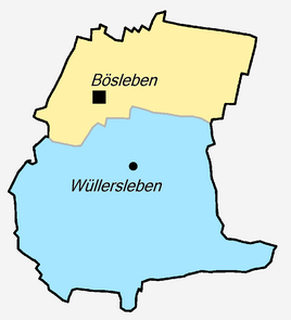
Location of Wüllersleben in Bösleben-Wüllersleben
|
|
Wüllersleben is a district of the municipality of Bösleben-Wüllersleben in the Ilm district ( Thuringia ) with around 280 inhabitants.
geography
Wüllersleben is about 400 meters above sea level on a plateau in the southernmost part of the Thuringian Basin . From the place you have a good view of the Steigerwald and the Fahner Heights to the north and west. To the south-east of Wüllersleben lies the Großer Holz, one of the few forest areas of the Riechheimer Berg administrative community to which the village belongs. The five kilometer long Dorfbach rises south of the village on Hopfenberg , then flows further north through Bösleben and then into the Wipfra .
history
At the beginning of the 9th century Wüllersleben was mentioned as Wlfriheslebo in a list of the goods of the Hersfeld Monastery founded by Archbishop Lullus († 786) of Mainz . The village developed from an old knight's seat, which however no longer existed during the Reformation .
Remnants of the rampart and moat bear witness to a former castle in the middle of the village. It probably also served as a mansion and to secure the surrounding area in the Middle Ages.
In the history of the place there were several major fires, the last time in 1905. Politically, the place belonged to the Stadtilm office in Schwarzburg-Rudolstadt ( suzerainty ) until 1920 . Then he came to the district of Arnstadt in the newly formed state of Thuringia . During the municipal reform of 1952, he was assigned to the Arnstadt district in the Erfurt district . On January 1, 1967, Wüllersleben was united with the neighboring Bösleben to form the municipality of Bösleben-Wüllersleben . In 1994 the place became part of the newly formed Ilm district based in Arnstadt .
A landmark of the place is the almost 50 meter high, widely visible church tower from the 19th century. The church, which was built between 1505 and 1513, is very large compared to the town, and maintaining it poses major problems for the small parish. The church is in dire need of renovation.
Economy and Transport
Like the villages in the area, Wüllersleben is characterized by agriculture. Wheat and corn cultivation as well as dairy farming are dominant. Roads connect Wüllersleben with Erfurt (20 km) and Bösleben (2 km) in the north, Arnstadt (9 km) and Marlishausen (4 km) in the west, Stadtilm (5 km) in the south and Rudolstadt (26 km) and Witzleben (3 km) ) in the East.
Personalities
- Gunther von Wüllersleben (1249–1252), Grand Master of the Teutonic Order
Web links
Individual evidence
- ↑ Michael Köhler: Thuringian castles and fortified prehistoric and early historical living spaces. Jenzig-Verlag, 2001, ISBN 3-910141-43-9 , p. 278

