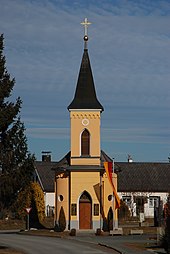
Wallendorf (Mogersdorf municipality)
|
Wallendorf ( village ) locality cadastral community Wallendorf |
||
|---|---|---|
|
|
||
| Basic data | ||
| Pole. District , state | Jennersdorf (JE), Burgenland | |
| Judicial district | Gussing | |
| Pole. local community | Mogersdorf | |
| Coordinates | 46 ° 58 ′ 20 ″ N , 16 ° 14 ′ 1 ″ E | |
| height | 231 m above sea level A. | |
| Residents of the village | 370 (January 1, 2020) | |
| Building status | 170 (2001) | |
| Area d. KG | 3.47 km² | |
| Statistical identification | ||
| Locality code | 00102 | |
| Cadastral parish number | 31129 | |
| Counting district / district | Wallendorf (10506 001) | |
| Source: STAT : index of places ; BEV : GEONAM ; GIS-Bgld | ||
Wallendorf is a district of the municipality of Mogersdorf and belongs to the Jennersdorf district in southern Burgenland in Austria . In 2007 Wallendorf had 372 inhabitants.
history
In the Magyar official language the place was called "Lapincsolaszi". In the dialect the pronunciation "Wolndöaf" and "Wolndoaf" is common. The oldest known mentions by name are Olafalw (1538), Olazfalw (1548), Olaszfalu (1552), Olazfalwa (1593), Olaszfalu seu Balendorff (1698), Olaszfalu seu Wallendorf (1764 to 1786), Ballendorf (1773). In etymological research, however, the name of the settlement "Wallendorf" is very controversial.
Mayor of the independent community of Wallendorf
| mayor | Political party | from | to |
|---|---|---|---|
| Josef scream | 1914 | 1920 | |
| Josef Kloiber | 1920 | 1927 | |
| Alois Zenz | 1927 | 1934 | |
| Johann Karner | 1934 | 1938 | |
| Rober Kloiber | 1938 | 1943 | |
| Eduard Haid | 1943 | 1945 | |
| Johann Karner | ÖVP | 1946 | 1947 |
| Johann Krenn | SPÖ | 1947 | 1954 |
| Emil Lederer | SPÖ | 1954 | 1958 |
| Franz Ring | SPÖ | 1958 | 1970 |
Culture and sights
- Local chapel of the Holy Trinity


