
Wallstrasse (Berlin)
| Wallstrasse | |
|---|---|
|
|
|
 |
|
| View from the tower of the Märkisches Museum to Wallstrasse | |
| Basic data | |
| place | Berlin |
| District | center |
| Created | before the 19th century |
| Connecting roads |
Märkisches Ufer |
| Cross streets |
Neue Grünstrasse , Neue Roßstrasse , Inselstrasse |
| Places | Märkischer Platz |
| Buildings | see → here |
| use | |
| User groups | Road traffic |
| Technical specifications | |
| Street length | 900 meters |
The Wall Street is a 900-meter-long street in the Berlin district of Mitte in the same district . It is located in the historic district of Neu-Kölln and was built in the middle of the 17th century near the Köpenicker Tor of the Memhardt city fortification , from which its name comes.
course
.jpg)
The approximately 900 meter long street begins at Spittelmarkt , runs in a north-easterly direction approximately parallel to the Spree Canal to the street Märkisches Ufer , into which it merges.
The underground line 2 will pass under Wallstraße for a length of about 650 meters . There are two underground stations along the street: Spittelmarkt and Märkisches Museum .
Explanation of the name
Wallstrasse has been named after around 1800 along the entire length between Spittelmarkt and Waisenbrücke. There are sources that indicate that Wallstraße was named as early as 1786, but until 1789 the street was always referred to as Neu Cöln , and in 1792 as Neu Cöln or Wallstraße .
history
In the 17th century one of the earlier districts of Berlin, called Neu-Kölln, was built . One of his traffic routes ran along the Memhardt fortifications on a separately heaped up rampart , but had no name of its own. When parts of the fortress were demolished from 1737 onwards, the road was built on both sides up to the former Green Ditch .

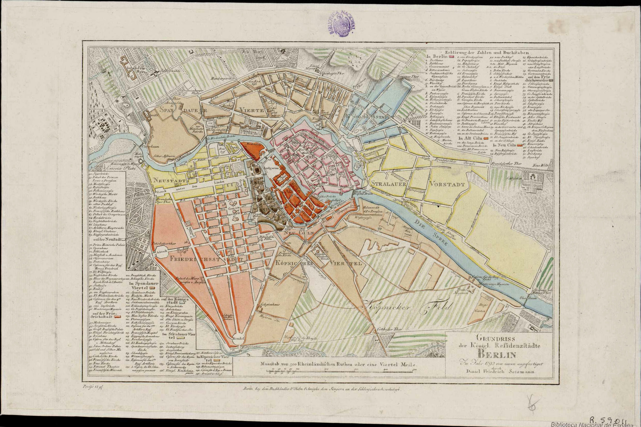
From 1738 today's street was called Neu-Cöln along its length from Gertraudenhospital to Waisenbrücke. On the Sotzmann map from 1792, the street is labeled Neu Cöln or Wallstraße . From the end of the 18th to the beginning of the 19th century, the part between Neuer Roßstrasse and Waisenbrücke was popularly known as Siropsgasse , after the syrup factory located here (on the site of the later New Hospital ) . From 1803, the full length of the street is referred to as Wallstraße in maps.
At the turn of the 20th century, large commercial buildings for important Berlin companies such as Ravené and Spindler were built, particularly on the south side of the street . At the northern end of the street, at what was then Märkischen Platz, the Märkisches Museum was completed in 1907 . In 1908 the Spittelmarkt underground station went into operation and was the terminus of the second Berlin underground line and had a connection to the terminus at Warschauer Brücke and Knie via the Gleisdreieck . In 1913, the subway was extended along Wallstrasse to Alexanderplatz and on to the then terminus Nordring . The Inselstraße underground station (now the Märkisches Museum) was built between Neue Roßstraße and Inselstraße .
From 1926 trams also ran through Wallstrasse in the section between Spittelmarkt and Inselstrasse. The line, inaugurated on November 2, 1926, was created during the redesign of the Spittelmarkt as a replacement for an older connection that led over the New and Old Jakobstrasse and Seydelstrasse. As early as 1900 there were plans to extend the Berlin – Hohenschönhausen tram over Wallstrasse to Spittelmarkt, but this was rejected at the time due to the narrow street width.
During the Second World War, numerous buildings were destroyed, especially in the eastern section. From 1966 to 1967 a school complex consisting of two schools and two gyms was built between Wallstrasse and Neuer Jakobstrasse, on the former site of the Lodge for the Three Worlds , based on designs by the J. Seifert planning collective.
The tram route leading through Wallstrasse with its continuation to Leipziger Platz was shut down on August 24, 1970. The tracks were in the pavement until 1998.
Between 1990 and 2020, almost all of the gaps caused by the destruction of the war were mostly built on with residential buildings. A new gymnasium and auditorium were built on the school site, Wallstrasse 32, with the meanwhile three school buildings. The southern school building has housed the Berlin Mitte theater house since 2009 .
Special buildings and monuments

→ List of cultural monuments in Berlin-Mitte / Neu-Kölln - monument areas (ensemble)
→ List of cultural monuments in Berlin-Mitte / Neu-Kölln - monument areas (complete systems)
→ List of cultural monuments in Berlin-Mitte / Neu-Kölln - architectural monuments
- No. 15 / 15a: The gold, silver and watch wholesaler Richard Lebram built a commercial building on the corner of Neue Grünstraße in 1911 (architects: Hoeninger & Sedelmeier). The building was one of the most modern of its time, equipped with elevators, a telephone network, pneumatic post , central heating, washrooms and a dining room for employees.
- No. 42: Between 1865 and 1868, the new building for the Kölln high school was built on the corner of Inselstraße according to plans by Adolf Gerstenberg.
- No. 52–54: In 1907 the Märkisches Museum was completed according to plans by Ludwig Hoffmann . It was created in the Köllnischer Park, which was laid out in 1883 .
- No. 61–65: The General German Trade Union Confederation built an office building on the corner of Inselstrasse from 1922 to 1923 based on plans by Max Taut and Franz Hoffmann . From 1930 to 1932 it was expanded by Walter Würzbach .
- The embassies of Brazil (No. 57), Angola (No. 59), Kosovo (No. 65), and Australia (No. 76–79; monument) are located on Wallstrasse .
literature
- Institute for Monument Preservation (Ed.): The architectural and art monuments of the GDR. Capital Berlin, I . Henschelverlag, Berlin 1984, p. 250 ff .
Web links
- Wallstrasse. In: Street name lexicon of the Luisenstädtischer Bildungsverein (near Kaupert )
Individual evidence
- ^ Sotzmann plan, 1803
- ↑ Map de Berlin, 1789
- ^ Sotzmann plan, 1792
- ^ Walter Plan, 1738.
- ^ Fidicin: Berlin, historically and topographically represented , p. 174, edition 1848.
- ^ Reinhard Schulz: Tram in turbulent times. Berlin and its trams between 1920 and 1945 . In: Verkehrsgeschichtliche Blätter . Volume 4, 2005, pp. 94-110 .
- ^ Author collective: Tram Archive 5. Berlin and the surrounding area . transpress, Berlin 1987, ISBN 3-344-00172-8 , pp. 112-115 .
- ↑ Architecture Guide of the GDR - Berlin, Capital of the GDR , Berlin 1976, p. 91.
- ↑ Sigurd Hilkenbach, Wolfgang Kramer: The tram in the Berlin Transport Authority (BVG East / BVB) 1949-1991 . transpress, Stuttgart 1999, ISBN 3-613-71063-3 , pp. 18-19 .
- ^ Theaterhaus Berlin Mitte: Production center for independent theater . Kulturinitiative Förderband gGmbH, accessed on October 12, 2019.
- ↑ Under the microscope - The Berlin gold, silver and watch wholesaler Richard Lebram. on www.archivspiegel.de
- ↑ Wallstrasse 76-79, 1912/1913 by Fritz Crzellitzki
_SLUB.jpg)
Coordinates: 52 ° 30 ′ 41 ″ N , 13 ° 24 ′ 26 ″ E